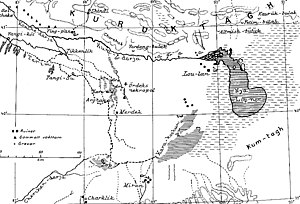
Karakoshun
The freshwater lake Karakoshun (= Kara Koshun, translation: black ground, black area = qara qosun = Hara kurtschin = Karahoshun) was located in the southwest of the Lop Nor desert, northeast of the village and the destroyed fortress of Miran in Xinjiang, from 1725 to 1921 , China. It lay in two separate basins, the small Kara Buran and the larger Kara Kurtschin (the actual Karakoshun), both of which are located at a height of 790 m and, together with the 780 m high basin of Lake Lop Nor, are in an 800 m high depression are located.
The brown crust of the earth and the rock-hard but thin white salt crust that coats the bottom of the dried out Karakoshun is deceptive; because a dangerous swamp is already half a meter below the surface (according to Christoph Baumer, status 1994).
Research history

Nikolai Michailowitsch Prschewalski went to Lake Karakoshun in 1876 and mistakenly thought that it was Lake Lop Nor . He explored the south and west banks and drove the Karakoshun half its length. The very shallow but open water then turned into a dense, no longer navigable reed vegetation, only to ebb away in the desert. In his diary he wrote: The desert has conquered the river, death conquered life. There were doubts among geographical experts as to whether Nikolai Mikhailovich Prschewalsky had actually found Lop Nor.
Stieler's Handatlas 1891 took over the information from Nikolai Michailowitsch Prschewalski and gave the Karakoshun the name Lob Nor .
The important German China researcher Ferdinand von Richthofen claimed that Prschewalski probably did not discover Lake Lop Nor, but another lake, since Lop Nor can be found on the Chinese maps about two degrees of latitude further north. Nikolai Mikhailovich Prschewalsky, in turn, questioned the reliability of the Chinese maps. Several Russian, English and French expeditions now turned to Lop Nor, but they mainly followed in Prschewalski's footsteps and went to the Karakoshun.
In 1901 the Swedish geographer and explorer Sven Hedin put an end to this dispute. He followed the old Chinese maps and found Lop Nor, an almost dry, shallow lake overgrown with reeds. Sven Hedin gave an explanation for the fact that the Lop Nor lake dried up: The masses of sand and mud previously carried along by the Kum-darja, which settled in the Lop Nor, slowly lifted the lake basin, while the storms eroded the dry lake basin of the southwestern Karakoshun would have. The Konch-darja then filled the now deeper lake basin of the Karakoshun with river water. That is the reason why the Lop Nor and its tributary Kum-darja had no water in the 19th century.
Sven Hedin called the Lop Nor a “wandering lake” and the tributary a “nomadic river”. This “spatial variability” (Hedin) was repeated several times, the last time in 1921. Then the Konch-darja again supplied the Kum-darja and the Lop Nor with water, while the Karakoshun dried up again.
In the years 1980–1981, a research group from the Chinese Academy of Sciences led by Xia Xuncheng toured the Lop Nor desert and created a map with the two separate lake basins Karakoshun and Lop Nor. The question of whether it is correct to name Lake Karakoshun as Lake Lop Nor and whether Sven Hedin is correct in naming Lake Lop Nor as a “migratory lake” is answered by the Chinese scientists of the Chinese Academy of Sciences in the book The Mysterious Lop Lake says no. The two lakes not only had a different geographical location in the 20th century, but they also had a different altitude (Lake Lop Nor 780 m above sea level, Lake Karakoshun 790 m).
Remarks
- ↑ Sven Hedin speaks of 1720, Christoph Baumer of 1725 and Ferdinand von Richthofen of 1750.
- ↑ possibly Yixün of the Han annals
- ↑ The map can be found on page 55 of The Mysterious Lop Lake book.
literature
- Nikolai Michailowitsch Prschewalski: Journey from Kuldscha over the Thianschan to the Lob-Nor. In: Petermanns Mitteilungen , supplement 53, Gotha 1878
- Sven Hedin: Through Asia's deserts . Volume 2. FA Brockhaus, Leipzig 1899.
- Sven Hedin: In the heart of Asia . FA Brockhaus, Leipzig 1903.
- Sven Hedin: Lop-Nur (Scientific Results of a Journey in Central Asia 1899–1902, Vol. II). Stockholm 1905.
- Ellsworth Huntington: The Pulse of Asia. Boston / New York 1907.
- Albert Herrmann: Loulan. China, India and Rome in the light of the excavations at Lobnor. FU Brockhaus, Leipzig 1931, pp. 55-70.
- Sven Hedin: The Wandering Lake . FA Brockhaus, Wiesbaden 1965, and Leipzig (FA Brockhaus) 1937.
- Folke Bergman: Archaeological Researches in Sinkiang. Especially the Lop-Nor region. (Reports: Publication 7), Stockholm 1939 (English).
- Xia Xuncheng, Hu Wenkang (Eds.): The Mysterious Lop Lake. The Lop Lake Comprehensive Scientific Expedition Team, the Xinjiang Branch of the Chinese Academy of Sciences. Science Press, Beijing 1985 (bilingual English and Chinese throughout; expedition results from 1980/1981 with pictures and maps).
- Christoph Baumer: The southern silk road. Islands in the sand sea. Mainz 2002, ISBN 3-8053-2845-1 .
- Lop-nor . In: Encyclopædia Britannica . 11th edition. tape 16 : L - Lord Advocate . London 1911, p. 991 (English, full text [ Wikisource ]).
Web links
- Stieler's hand atlas 1891
- Map by Sir Aurel Stein. In: Serindia: detailed report of explorations in Central Asia and westernmost China . Volume 5. Oxford 1921.
Coordinates: 39 ° 37 ' N , 89 ° 20' E
