
Khami
| National Monument Ruins of Khami | |
|---|---|
|
UNESCO world heritage |
|

|
|
| National territory: |
|
| Type: | Culture |
| Criteria : | (iii) (iv) |
| Reference No .: | 365 |
| UNESCO region : | Africa |
| History of enrollment | |
| Enrollment: | 1986 (session 10) |
Khami is a ruin site in southwest Zimbabwe five kilometers west of Bulawayo .
The place was created in the 15th century when Greater Zimbabwe , the old center of power of the Munhumutapa Empire , was abandoned and its focus shifted north to the area around the Mazowe Valley . Since then Khami was the center of Torwa -state that the Mutapa competed -State. Finds of items produced in China or Europe show that the place was an important trading center. In the 17th century, the center of the Torwa State shifted eastward to Danangombe, 80 km away . Shortly thereafter, power passed to the Changamire dynasty, which ruled until 1831.
The current remains of the place consist of a palace complex, which was placed on a hill above the settlement, as well as the remains of stone walls and terraces. Compared to Greater Zimbabwe, these terraces are just as new as ornamental stone arrangements.
The place was declared a World Heritage Site by UNESCO in 1986 .
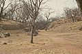
Khami: "street"

Khami: retaining wall with stone ornaments
.jpg)

See also
Web links
Individual evidence
- ↑ UNESCO World Heritage Center: Khami Ruins National Monument. Accessed August 21, 2017 .

Cultural heritage: Great Zimbabwe National Monument (1986) | National Monument Ruins of Khami (1986) | Matobo Mountains (2003)
Natural heritage: Mana Pools National Park , Sapi and Chewore safari areas (1984) | Mosi-oa-Tunya / Victoria Falls (1989)
Coordinates: 20 ° 9 ′ S , 28 ° 25 ′ E