Kitekite Falls
The Kitekite Falls (also Kitakita Falls ) are a three-tier waterfall near Auckland in New Zealand . The total drop height is 40 meters. From the lookout point at the kitekite track , the waterfall appears even higher, as the white water first falls from the upper pool over the rocks into a small pool, from there it falls into a large pool, then into another. Only then does the actual, almost vertical three-tier waterfall begin, so that the total height of the descent is almost 80 m. The falls are part of the Glen Esk Stream and are close to Piha Beach.
Access
A circular path was built from a parking lot at the end of Glen Esk Road , and around 30,000 people visit the falls annually. The path follows the south side of the Glen Esk Stream with a few interruptions to a lookout point, where a huge bench made of macrocarpa wood offers a view of the fall. The bank was set up in 2005 by criminals as a charitable work. The path then descends to the base of the fall and crosses the stream at the lower swimming hole , then continues down the north side of the river. Another path leads down a steep path, the Connect Track , which goes up about 100 meters north of the base of the waterfall on the north side. The pool at the top of the fall is suitable for bathing, but the water is cold.
history
Kauri wood was extracted in the area from 1910 .
First attempts to let trees down the falls resulted in their destruction on the rocks below the falls. Therefore, a wooden dam was built above the falls, of which only incisions in the rock are left today, in which the dam was anchored. In addition, parts of the heavy beams lie in the course of the waterfall. Now you were able to wash the logs with the additional water down the falls to the sawmill.
In 1921 the logging was stopped when all the adult trees had been felled.
Flora and fauna
It took many decades for the kauri trees ( Agathis australis ) to regenerate and break through the canopy of the forest again. Some trees, around 100 years old, can be seen from the circular path. These are still young trees with a slender tip. The kauri tree does not begin to expand its crown until it is around 100 years and then grows for another 500 years.
The path leads through a patch of Nikau palm trees . Tui birds live there . Other plants are Silberfarn and Puriri whose red berries -Trees (Vitex lucens) Maori fruit pigeons attract and Rangioroa (also because of the soft underside of her broad leaves -Pflanze bushman's friend called). The rare moss Fissidens rigidulus var. Pseudostrictus also grows in the cases .
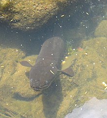
The New Zealand longfin eel , ( Anguilla dieffenbachii ) lives in the rocks at the foot of the falls.
Origin of name
'Kitekite' is a misspelling of the Maori name Kitakita . According to a dictionary, the word 'Kitakita' means colorful, tight, fast, intense.
The Glen Esk was so named by William Stockwell. He emigrated to New Zealand in 1876 and soon after his arrival bought land above the falls. He named the area "Glen Esk" after his home in Scotland . "Glen" is the Gaelic word for valley . "Esk" is of Celtic origin and means "water".
Canyoning
The falls are used by a licensed operator for canyoning . This license was the subject of heated discussions at the general assembly of the Piha Ratepayers and Residents Association in 2002 , as residents feared negative effects on the environment, which a representative of the nature conservation authority did not share. Canyoning continues to this day and is under observation. Getting off the trail and climbing the rocks is strictly prohibited and only possible with a permit or a licensed guide. In the wetlands where the rare moss grows, entry is forbidden.
gallery
See also
Web links
- Kitekite Track . Auckland Council,accessed August 25, 2014.
Individual evidence
- ^ New Zealand Geographic Placenames Database
- ↑ http://www.world-of-waterfalls.com/new-zealand-kitekite-falls.html New Zealand waterfalls by Johnny T. Cheng p. 44
- ^ Dept of corrections - Community Works, Issue 3, June 2005
- ↑ Day Walks of Greater Auckland (2003) by Marios Gavalas and Peter Janssen, Reed Publishing (NZ) Ltd. P. 63
- ^ "Kauri - New Zealand's Ancient Forest" p. 3, 2005
- ↑ Article by Margaret Turton, May 25, 2007
- ^ Waitakere Ranges Protection Society Inc. News Issue 124 Nov. 2004
- ↑ Pohutukawa Post, Winter 2005, p. 1. Article by Stu Leighton, ARC Park Ranger - This information is also on the information boards at the beginning of the trail
- ↑ http://www.maoridictionary.co.nz/ January 22, 2008
- ↑ More History . Piha , archived from the original on May 23, 2010 ; accessed on August 25, 2014 (English, original website no longer available).
- ↑ About AWOL Canyoning . AWOL Canyoning Adventures Ltd , archived from the original on January 17, 2008 ; accessed on August 25, 2014 (English, original website no longer available).
- ↑ Hot Issues Archive . Piha , archived from the original on October 14, 2008 ; accessed on August 25, 2014 (English, original website no longer available).
Coordinates: 36 ° 57 ′ 41 ″ S , 174 ° 29 ′ 21 ″ E


