Latimer Road (London Underground)
Latimer Road is an above-ground London Underground station in the Royal Borough of Kensington and Chelsea . It is in the Travelcard tariff zone 2 on Freston Road and is served by trains of the Hammersmith & City Line and the Circle Line . In 2014, 2.39 million passengers used the station.
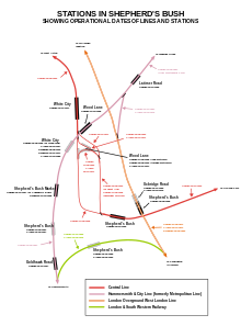
The station was opened on December 16, 1868 by the Metropolitan Railway (predecessor of the Metropolitan Line ). However, the line had already been opened in 1864 by the Hammersmith & City Railway , which initially belonged to the Great Western Railway and three years later became the property of the Metropolitan Railway.
Immediately south of Latimer Road branched off from 1864 to the south, which led to the Addison Road station - today Kensington (Olympia) - and was served by the Metropolitan Railway as part of the Outer Circle . This route was closed on October 19, 1940. In 1990 the Hammersmith branch of the Metropolitan Line became operationally independent under the name Hammersmith & City Line. Circle Line trains have also stopped here since December 13, 2009.
From today's perspective, it seems unusual that the station is named after Latimer Road, although this runs around 500 meters north of the station, the station in turn is south of the Westway , a multi-lane expressway. However, before the Westway was built (1964–1970), Latimer Road ran further south to the station. The construction of the expressway required the demolition of the middle section of Latimer Road, the separated southern section was renamed Freston Road. Even so, the station kept its original name.
Web links
Individual evidence
- ↑ COUNTS - 2014 - annual entries & exits. (PDF, 44 kB) (No longer available online.) Transport for London, 2015, archived from the original on February 21, 2016 ; accessed on December 29, 2017 (English). Info: The archive link was inserted automatically and has not yet been checked. Please check the original and archive link according to the instructions and then remove this notice.
- ^ Hammersmith & City Line. Clive's Underground Line Guides, accessed January 14, 2013 .
- ^ Circle Line. Clive's Underground Line Guides, accessed January 14, 2013 .
| Previous station | Transport for London | Next station |
|---|---|---|
| Wood Lane |
|
Ladbroke Grove |
| Wood Lane |
|
Ladbroke Grove |
Coordinates: 51 ° 30 '48.7 " N , 0 ° 13' 3.9" W.


