List of cultural monuments in Zschornau
The list of cultural monuments in Zschornau includes the cultural monuments of the Kamenz district of Zschornau , which were recorded by the State Office for Monument Preservation of Saxony until July 2017 (excluding archaeological cultural monuments). The notes are to be observed.
Zschornau
| image | designation | location | Dating | description | ID |
|---|---|---|---|---|---|
 |
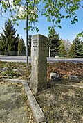
Waystone | At the airfield (corner of Auenweg) (map) |
19th century | Significant for traffic history, roughly hewn granite stele tapering slightly upwards, smoothed in the upper part and provided with carved location and kilometer information as well as directional arrows, above it a flat pyramidal closure |
09304086 |
 More pictures |
Prayer pillar | At the airfield (map) |
1564 | Granite stele with niche containing a wooden figure of St. Christophorus, originally intended, of artistic and cultural significance |
09284057 |
 |
Memorial to the fallen of the First World War | At the airfield (corner of Auenweg) (map) |
After 1918 | Granite obelisk, of local historical importance, restored |
09284056 |
 |
Residential stable house, side building and barn of a three-sided courtyard, with a courtyard entrance with an archway and small side gate openings, plus an iron hand pump | At airfield 1 (map) |
2nd half of the 19th century | Plastered buildings with a gable roof, of architectural and economic importance |
09284070 |
 |
School with attached outbuilding | Am Flugplatz 16 (map) |
Marked 1878 | Wilhelminian style plastered building with a gabled central projectile, inscription “Point the children to me”, of importance in terms of building history and local history |
09284055 |
 More pictures |
Eastern side building and barn of a farm as well as courtyard entrance with archway and right side arch | Am Mühlgraben 15 (map) |
Around 1800 | Side building upper floor half-timbered plastered, barn half-timbered, of importance in terms of building history and the street scene |
09284068 |
 |
Inn with hall and northern barn of a three-sided farm | Forstweg 2 (map) |
2nd half of the 19th century | Gasthof Putzbau with hall on the upper floor, stable part, saddle roof with bat dormers, barn plastered building with two large gates and saddle roof with bat dormers, of architectural and local importance |
09284064 |
 |
Enclosure wall with courtyard entrance with archway and left side gate | Forstweg 4 (map) |
19th century | Significant for the streetscape |
09284063 |
 More pictures |
Residential stable house and side building of a three-sided courtyard and enclosure wall with courtyard entrance and gate | Forstweg 14 (map) |
Residential stable house marked 1860 | Both buildings plastered quarry stone buildings with saddle roofs and dormer windows, courtyard wall with top made of clinker shaped bricks, important in terms of building history and the appearance of the street |
09284061 |
 More pictures |
Residential stable house, barn and side building of a three-sided courtyard and courtyard entrance with an archway and two smaller arches on the side | Forstweg 16 (map) |
Around 1850 | Plastered buildings with a gable roof, residential stable house with twin windows and three oculi in the gable, of importance in terms of building history and the appearance of the street |
09284060 |
Former monuments
| image | designation | location | Dating | description | ID |
|---|---|---|---|---|---|
| Residential stable house | Am Mühlgraben 19 (map) |
Around 1800 | Upper floor half-timbered partly plastered, partly boarded up, of architectural significance; Removed from the list of monuments after 2014 |
09284069 |
|
| House and angled side building of a homestead | At airfield 20 (next to) (map) |
Outbuilding marked 1656 | Upper floor residential building timber-framed, marked with "1656 FC" in the weather vane, of importance in terms of building history and house history; demolished between 2018 and 2020 |
09284058 |
Remarks
- This list is not suitable for deriving binding statements on the monument status of an object. As far as a legally binding determination of the listed property of an object is desired, the owner can apply to the responsible lower monument protection authority for a notice.
- The official list of cultural monuments is never closed. It is permanently changed through clarifications, new additions or deletions. A transfer of such changes to this list is not guaranteed at the moment.
- The monument quality of an object does not depend on its entry in this or the official list. Objects that are not listed can also be monuments.
- Basically, the property of a monument extends to the substance and appearance as a whole, including the interior. Deviating applies if only parts are expressly protected (e.g. the facade).
swell
- List of listed monuments of the State Office for the Preservation of Monuments in Saxony, as of April 15, 2014
- Monument map of Saxony , accessed on July 31, 2017
Individual evidence
- ↑ Geoportal of the district of Bautzen. In: cardomap.idu.de. Bautzen district office, accessed on July 31, 2017 .
Web links
Commons : Cultural monuments in Kamenz - Collection of images