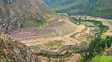
Llactapata
Llactapata , in Quechua Llaqtapata is an Inca city in Peru .
The name is derived from the Quechua words llaqta ("city", "village") and pata ("terrace", "step", "on"). The city is also called Patallacta or Patallaqta .
It is located in the Urubambatal in the Peruvian region of Cuscoin, 80 kilometers northwest of the city of Cusco . The ruined city is about 2500 meters above sea level . Machu Picchu , also a ruined city of the Inca, is 15 kilometers to the northwest . In contrast to Machu Picchu, Llactapata is not located on a mountain top, but directly on the Urubamba River .
The outer walls of the houses are still standing, the city was not destroyed during the Spanish conquest. At first there were maybe ten or a dozen buildings that made up the fortress. During the Inca rule, the city was at a strategically important point.
Large areas of the city were used as cultivation areas. Mostly potatoes and corn were grown . The Inca also used maize to produce chicha , an alcoholic and beer-like drink used for ritual purposes .
The Inca fortress Llactapata was connected to the well-developed road network in the Inca Empire .
Bibliography
- Lars Abromeit ao: Maya, Inca, Aztec: the ancient American empires; 2600 BC BC to AD 1600 (= Geo epoch, 15). Gruner and Jahr, Hamburg, 2004, ISBN 3-570-19450-7 .
Web links
- J. McKim Malville, Hugh Thomson, Gary Ziegler: Machu Picchu's Observatory: the Re-Discovery of Llactapata and its Sun-Temple. In: clara.net. November 16, 2004 (English).
Coordinates: 13 ° 13 ′ 52.2 " S , 72 ° 25 ′ 29.2" W.
