Loch Nant
| Loch Nant | ||
|---|---|---|

|
||
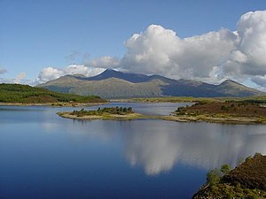
| Loch Nant seen from the southwest | ||
| Geographical location | Argyll and Bute, Scotland | |
| Tributaries | Abhainn Cam Linnhe | |
| Drain | Pipelines to Loch Awe | |
| Data | ||
| Coordinates | 56 ° 21 '52 " N , 5 ° 14' 30" W | |
|
|
||
| Altitude above sea level | 201 m | |
| surface | 1.12 km² | |
| length | 1.3 km | |
| width | 1 km | |
Loch Nant is a Scottish reservoir . It is located in the district of Lorn in the Council Area Argyll and Bute about 4 kilometers northwest of Loch Awe . The lake is part of the Sloy-Awe Hydro-Electric Power Scheme , which is used to generate electricity from hydropower.
Loch Nant is about 1.3 km long and on average about 1 km wide. The lake gets its water mainly from Abhainn Cam Linnhe and largely drains through underground pipes that direct the water from the lake to a hydroelectric power station on Loch Awe.
The banks of Loch Nant are completely uninhabited and appear largely as grassland. The lake is not accessed by any road. Even the dam wall on the north bank can only be reached via a largely unpaved road from the B848.
Web links
Commons : Loch Nant - collection of images, videos and audio files
- Description of the lake ( English )
- Information for hikers ( English )
- Migration to the hole Nant (film) ( English )
