
Lollands Østerborg

Lollands Østerborg, north of Godsted on the island of Lolland in Denmark , is the largest Iron Age Fornborg in Denmark with around 4.0 km² and the second largest of this type in the north.
Lolland Østerborg is next to "Lollands Vesterborg" and "Falsters Virke" one of three castles on Lolland and Falster . While Falsters had known Virke for some time, it was GU Haugner, the editor of the Nakskov Journal (also local historian and politician, the initiator of the construction of the Reventlow Museum of Pederstrup), who in 1928 presented the idea that in the middle Lollands are the remains of a fortress and that such a castle was probably also on West Lolland. He identified parts of an enclosure between Lake Hejrede, Maribo Søndersø and Røgbølle Lake. The lakes in the north and south, together with ramparts in the east and west, delimit a large area that represents the castle complex.
- Lollands Østerborg
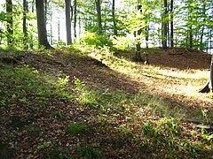


The still intact eastern part is in Karup Vænge, a forest south of Lake Hejrede on the border between Musse and Fuglse Herred. The castle was already examined in 1944, but the ramparts only gained general notoriety through an article by Harald Andersen and Sven Thorsen in the popular science magazine Skalk in 1992 and 1993. In 1995 new investigations were carried out on the spot, and it turned out found out that GU Haugner's view was correct and that the system dates from around 550 AD.
use
There are several theories about the original function of the systems. Although the buildings suggest a defensive structure, this is difficult to secure given the size. Therefore, the Fornborgar are compared with Slavic castles , which, like the later medieval cities, were protected dwelling places and religious centers. The function as a refuge is also considered for some, but it should be a uniform reason for use.
The passage grave in Lars Jensens Skov is on the site of Lollands Østerborg west of Røgbøllevej.
literature
- Kirsten Christensen: Hejrede og Søholt - et forsvarsanlæg. Under Storstrom's sky. Kulturlandskabet i Storstrøms Amt. 1996
- SKALK 2001 no. 5
- Michael Olausson: Det inneslutna rummet - om kultiska hägnader, fornborgar och befästa gårdar i Uppland från 1300 f.Kr till Kristi födelse. Riksantikvarieämbetet Arkeologiska undersökningar Skrifter nr 9. Stockholm 1995
See also
Coordinates: 54 ° 44 ′ 10.7 " N , 11 ° 35 ′ 36.3" E