Masel (Sprakensehl)
|
Masel
community Sprakensehl
|
|
|---|---|
| Coordinates: 52 ° 45 ′ 7 ″ N , 10 ° 30 ′ 55 ″ E | |
| Residents : | 97 (Sep 1, 2016) |
| Incorporation : | March 1, 1974 |
| Postal code : | 29365 |
| Area code : | 05837 |
|
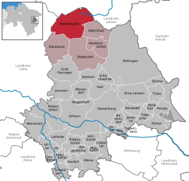
Location of the municipality of Sprakensehl in the district of Gifhorn
|
|
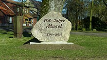
Masel is a district in the north of the municipality of Sprakensehl , district of Gifhorn in Lower Saxony and has 97 inhabitants.
geography
location
Masel is located in the southern part of the Lüneburg Heath .
Population development
- 2010: 94
- 2016: 97
Associations and associations
- Masel shooting club
Economy and Infrastructure
Companies
- In Masel there is a camping site (Waldcamp Südheide), formerly Pension Adebahr
- The contractor Steffen Prilop is also based in Masel.
traffic
The state road 280 and the district road K8 run through Masel .
Web links
http://www.gemeinde-sprakensehl.de/
Individual evidence
- ↑ http://www.gemeinde-sprakensehl.de/index.html
- ↑ http://www.gemeinde-sprakensehl.de/index.html
- ↑ https://www.sg-hankensbuettel.de/unsere-samtgemeinde/einwohnerzahlen/
- ↑ http://www.az-online.de/lokales/landkreis-gifhorn/hankensbuettel/ziel-idyllischer-urlaubsort-2468401.html
- ↑ http://www.facebook.com/WaldcampSudheide
- ↑ http://www.lu-prilop.de/index.html


