
Massif de Marseilleveyre
The Massif de Marseilleveyre is a rugged, karstified mountain range south of Marseille . Its spectacular fjord-like bays are part of the Calanques .

geography
Deep valleys and gorges such as the Grand Malvallon, the Vallon de la Mounine or the Vallon des Aiguilles only lead to water in the streams on the valley floor after rainfall. Numerous caves such as the Grotte de l'Ours, the Grotte de l'Eremite or the Aven Gombault, karst springs such as the Fontaine de Voire or the Fontaine de Brès and bizarre rock formations such as the natural stone arch Les Trois Arches in the upper Malvallon characterize the massif. Numerous hiking trails and climbing routes run through the mountains. The Col de la Selle and the Col des Chèvres to the east and west of the Sommet de Marseilleveyre, respectively, make it possible to traverse the mountain range in a north-south direction.
Toponymy
The name of the massif means massif from which you can see Marseille (veyre = Occitan 'see').
vegetation
The naturally barren vegetation is also reduced by recurring forest fires. Typical plants are the Aleppo pine , the garrigue and occasional pine and cypress trees . Forests can only be found at the northern foot of the massif and in the Bois de la Selle below the Col de la Selle.
Notable surveys
- Sommet de Marseilleveyre , 432 m, highest point of the massif
- Béouveyre , 397 m
- Tete de l'Homme , 396 m
- Tete de la Mounine , 385 m
- Sommet Ouest de l'Homme Mort , 374 m
- Tete de la Melette , 362 m
- Pointe Callot , 346 m
- Les Trois Pics , 335 m
- Rocher St. Michel , 322 m
- Tete du Trou du Chat , 281 m
- Rocher des Goudes , 258 m
Web links
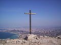
Summet cross of the Sommet de Marseilleveyre
The Marseilleveyre massif seen from Mont Puget

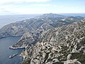
The Tete du Trou du Chat and the Rocher St. Michel


Coordinates: 43 ° 13 ′ 12 ″ N , 5 ° 22 ′ 9 ″ E