Maximilianstrasse (Speyer)

The Maximilian Street is the main shopping street of the city of Speyer and the former Boulevard, Via Triumphalis , the old imperial city.
history
Maximilianstrasse was laid out in the 11th century in connection with the construction of the cathedral and the first city expansion that followed. Since that time it has been Speyer's main street and is still called that by the population today. It runs in an east-west direction between the cathedral and the old gate and divides the medieval old town into two parts. The widest street in the city served not only as a thoroughfare, but also as a market square. The Obere Markt followed on from Domplatz up to number 6 . This was followed by the Weinmarkt up to the junction with Schrannengasse and the market square up to the former mint . Between the coin and the Ledergässel was the leather market , to the junction of Eichgässels the onion market , and finally in front of the old gate Krämergasse . In 1740 the street was already called "Hauptstraße" and in 1773 "Breite Straße". Until the end of the 18th century it was the only street in Speyer that was called "Straße"; otherwise there were only alleys. It was not until 1816, when the Palatinate came to Bavaria , that it was renamed Maximilianstrasse after King Max I Joseph .
The first section of the street between the cathedral and the Alte Münz was built on the site of a wide ditch that separated the southern episcopal town from the northern Gaugrafensiedlung. The further section up to the old gate was created in the early Middle Ages as the city was expanded. It is assumed that the development between Maximilianstrasse and Korngasse developed from market stalls, so that the main street was originally twice as wide. The Speyerbach, which was not covered until the 19th century, runs between the Altpörtel and Münz.
course
Maximilianstrasse is about 600 meters long and not evenly wide; the narrowest point is at the Alte Münz. There were several jumps between the coin and the old gate, as can still be seen from the basement rooms that extend far below the street. These jumps resulted in a division of the market sections, but this was not resumed after the city was destroyed in 1689. A square-like extension can be found in front of the old gate.
After the withdrawal of the French in 1930, a memorial for the fallen of the (First) World War in the form of a fountain was erected on the market square in front of the Münz . One of the reliefs depicting two soldiers throwing grenades was removed in 1947. The others, which from today's point of view also appear to be nationalistic and glorify violence, were retained, but provided with a sign indicating the historical classification.
As part of the city's 2000 year celebrations, Maximilianstrasse was completely redesigned and is largely free of traffic. In the period that followed, a number of street cafes were created. To the south of the old gate, the Rossmarktstraße joins with the original old Rossmarkt that gives it its name.
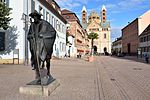
While today business life is concentrated on the western two thirds of the street, the eastern third is the seat of numerous public institutions (police, town hall, social welfare office, town hall, episcopal ordinariate). Approximately in the middle between the Alter Münz and the cathedral, on the north side of the street, there is a square (Gscherrplätzl) that offers a view of the Trinity Church and on which there is a small fountain. On the street there is a sculpture of a pilgrim who reminds us of Speyer as the starting point or station on the Way of St. James .
architecture
The historical ground plan of the buildings was preserved after the destruction in 1689 and the small-scale buildings often date from the 18th century. In most cases it was residential and commercial buildings. Before the city fire, the buildings were significantly higher, three to four floors; the reconstruction was inconsistent. Up until the middle of the 19th century, the development on the north side was mostly two-storey, eaves and simple, while representative higher gable buildings of the urban patriciate were built on the south side. Most of the buildings on Maximilianstrasse are listed; due to the fire of 1689 there are hardly any older buildings to be found. However, the city had better luck in World War II and experienced almost no damage in the historical core.
The street itself consists of large cobblestones and is bordered on each side by sidewalks of different widths, on which there are continuous slabs to prevent wheelchairs, strollers or shoe heels from getting stuck in the sometimes rough joints.
Events
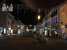
Maximilianstrasse is the location of several regular business and cultural events. The Christmas market, the annual parade of the Speyer pretzel festival or the Speyer Kaisertafel, an almost continuous table from the old gate to the cathedral with many offers of food and drink, take place in the middle of the street. Other events are the Speyer Spring Festival and the Kult (o) urnacht.
traffic
Maximilianstraße is connected at least every 15 minutes with the city bus lines 564/565 & 568 with the main train station, Speyer Nord, Kurbaxx, Süd and Römerberg. There are 4 bus stops Dom / Stadthaus, Maximilianstraße, Wormser Straße and Postplatz. At events, Maximilianstraße is often closed to bus traffic, and a replacement stop is used in Ludwigstraße on Königsplatz.
literature
- Cultural monuments in Rhineland-Palatinate, Vol. 1, City of Speyer, 1st edition 1985, Schwann, Düsseldorf, ISBN 3-590-31031-6


