
Maximinstrasse (Trier)
| Maximinstrasse | |
|---|---|
|
|
|
 |
|
| Baroque portal building in the street | |
| Basic data | |
| place | trier |
| District | North |
| Connecting roads | Thebäerstrasse, Maximinstrasse |
| Cross streets | Petrusstrasse, Alkuinstrasse |
| Buildings | Imperial Abbey of St. Maximin , officers' casino |
The Maximinstraße is a street in Trier in the district of North . It runs between Thebäerstrasse and St. Maximin School in the east and Paulinstrasse in the west. At its end point it turns into Maarstrasse .
history
The street is named after the Trier bishop Maximin , who was buried in the former church of St. John. The street represents the old access route to the Imperial Abbey of St. Maximin , which was built in place of his grave.
Cultural monuments
In the street there are six cultural monuments , including a baroque portal building with a gabled sandstone square gate with two abbot coats of arms, from the second half of the 18th century. The architect was probably Christian Kretzschmar . Maxmininstrasse is also part of the Maximinstrasse 22–30 monument zone .

Trier, Maximinstraße 1: three-storey residential building with elaborate floral and figurative decor, 1903, architect C. Walter

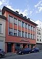
Trier, Maximinstrasse 18, former officers' dining establishment; Elaborately designed neo-renaissance building in a corner, accentuated by a three-storey tower with hipped roof, 1901

Trier, Maximinstraße 28, late classicist five-axis house, 1864
Trier, Maximinstraße 31, former cinema atrium


literature
- Patrick Ostermann (arrangement): Cultural monuments in Rhineland-Palatinate. Monument topography Federal Republic of Germany. Volume 17.1: City of Trier. Old town. Werner, Worms 2001, ISBN 3-88462-171-8
- Ulrike Weber (edit.): Cultural monuments in Rhineland-Palatinate. Monument topography Federal Republic of Germany. Volume 17.2: City of Trier. City expansion and districts. Werner, Worms 2009, ISBN 978-3-88462-275-9 .
- General Directorate for Cultural Heritage Rhineland-Palatinate (publisher): Informational directory of cultural monuments of the district-free city of Trier. (PDF; 1.2 MB) Koblenz 2010.
- Kulturbüro der Stadt Trier (ed.) / Emil Zenz: Street names of the city of Trier: their sense and their meaning. Trier 2003.
Individual evidence
- ↑ Kulturbüro der Stadt Trier (ed.) / Emil Zenz: Street names of the city of Trier: their sense and their meaning. Trier, 2003.
- ^ Patrick Ostermann (arrangement): Cultural monuments in Rhineland-Palatinate. Monument topography Federal Republic of Germany. Volume 17.1: City of Trier. Altstadt.Werner, Worms 2001
- ↑ List of monuments of the General Directorate for Cultural Heritage, Rhineland-Palatinate; 2010.
Coordinates: 49 ° 45 ′ 39.2 " N , 6 ° 38 ′ 57.3" E