
Mizuma-dera

The Mizuma-dera ( Japanese 水 間 寺 ) with the mountain names Ryūkokusan ( 龍谷 山 ) and Kannon-in ( 観 音 院 ) is a temple of the Tendai direction of Buddhism in Kaizuka ( Osaka Prefecture ). It is the 4th temple of the New Saigoku Pilgrimage .
history

According to tradition, the temple was built by priest Gyōki in 744. In 1585 it was fought by Hashiba Hideyoshi's general Hori Hidemasa ( 堀 秀 政 ; 1553-1590) and largely destroyed, the remains were torn down. In the Edo period , the temple was rebuilt at the request of the heads of the Kishiwada-Han, the Okabe during the Genroku era (1668-1704). In 1784 the temple was destroyed again by a fire, reconstruction began with the completion of the main hall in 1811. The other buildings in the complex were gradually added.
investment
From the Mizuma train station of the Mizuma Railway Company, which was established in 1926, it is 500 m to the bridge over the Kogi River ( 近 木 川 ; Ko on the map), which is called the " Doom Defense Bridge" ( 厄 除 け 橋Yakuyoku-hashi ). It leads to the open temple area, which apart from the abbot and monk's quarters has no walls or gates. At the rear in the southwest, the temple is bounded by the Kibitani River ( 秬 谷川 Ki ), which flows a little further into the Kogi.
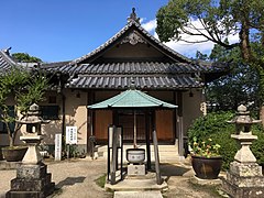
In the middle of the complex is a three-story pagoda ( 三重 塔 Sanjū-no-tō ; 1) and behind it the main hall ( 本 堂 Hondō ; 2). Further to the right above the Kibitani River is the bell tower ( 鐘楼 Shōrō ; 3) and the sutra store ( 経 蔵 Kyōzō ; 4). The Jōshakkō Hall ( 常寂 光 堂 ; 5) can be found on the right edge of the facility .
In the abbot and monk's quarters (A) you will find the Aizen Hall ( 愛 染 堂 ; 6), which is dedicated to the King of Heaven Aizen ( 愛 ig 明王 ). In the west, a slightly curved drum bridge (B) leads to the temple.
photos

pagoda
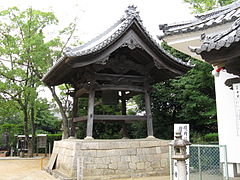
Temple bell

Sutra pavilion
Jōshakkō Hall
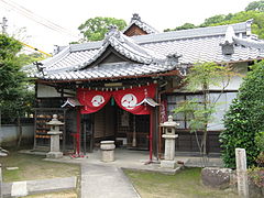
Aizen hall
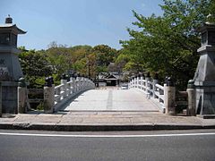
Drum bridge


literature
- Osaka-fu no rekishi sampo henshu iinkai (ed.): Mizuma-dera . In: Osaka-fu no rekishi sampo (ge). Yamakawa Shuppan, 2007. ISBN 978-4-634-24827-4 . P. 270.
Web links
Coordinates: 34 ° 23 '55.9 " N , 135 ° 23' 8.2" E