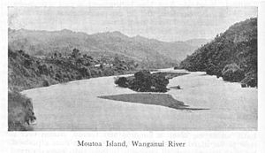
Moutoa Island
| Moutoa Island | ||
|---|---|---|
| Depiction of the island in the middle of the 19th century | ||
| Waters | Whanganui River | |
| Geographical location | 39 ° 34 '41 " S , 175 ° 5' 24" E | |
|
|
||
| length | 500 m | |
| width | 100 m | |
Moutoa Island is a 500 m long gravel island in the Whanganui River in New Zealand . It is located about 80 km from the mouth of the river in the Tasman Sea between the communities of Ranana and Hiruharama .
The island is surrounded by rapids and has been the site of many Māori battles . The most important took place on May 14, 1864 between a force of supporters from Pai Marire from the upper reaches of the Whanganui and the Ngati-Hau from the lower reaches of the Whanganui during the Second Taranaki War .
The city of Wanganui was a thriving settlement that was economically important for Māori tribes on the lower reaches of the city. The tribes of the warring Hau Hau on the upper reaches, hostile to the European settlers ( Pākehā ) , decided to burn the city down and drive the Pākehā into the sea. The tribes on the lower reaches made it clear that they did not agree.
Interestingly, the battle went back to the now outdated Māori warfare practices: the battle was to take place at a predetermined time at a predetermined time. That place was Moutoa Island in the Wanganui River. 100 defenders of the Ngati-Hau arrived first and positioned themselves across the island. Then 120 Hau Hau warriors landed on the north side of the island. The ceremonial war dance haka was performed. Believing that they were invulnerable, as their prophet had told them, the Hau Hau now advanced against the guns of the defenders. When the smoke cleared, two-thirds of them were dead or wounded, including their prophet, and the rest withdrew.
Wanganui was saved and the grateful citizens erected a memorial in honor of the 15 Māori who fell in defense.
Web links
- New Zealand History : Was in Whanganui - Moutoa Island. Accessed August 21, 2019 .

