Neoglacial Alseksee
The neoglacial Alseksee was last formed several times from Lowell Lake in the Little Ice Age .
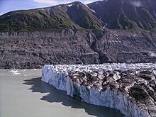
The Lowell Glacier , a 70-kilometer-long ice stream in the St. Elias Mountains in Canada's Yukon Territory , formed a dam through which the Alsek River was dammed.
Sudden breaks in this glacier dam in 1725 and 1852 triggered huge tidal waves. The wall of water, interspersed with rubble and ice, shot down the valley and tore everything with it, 200 km into the Pacific. The Tlingit Indians living in the lower Alsek Valley and Dry Bay and their culture have been largely wiped out.
Reported eyewitness account
Emma Ellis tells the story of her grandmother, an eyewitness in 1852, then ten years old:
“There was a flood all over. It was because my father's people (TlukwaxAdi) made fun of a seagull. They threw it in the fire. It was a young one and couldn't fly. They threw it in again. All its feathers burned off. They laughed at it. And then a great flood came. And there was no place to be safe. That glacier broke that used to go across the Alsek. The people tied their canoes to the 'Whale's fin.' That island at the mouth of Dry Bay, GAltcinuwu, used to be a whale, and the people tied their canoes to the part sticking up. But some of the young people untied their canoes too soon. A great wave came along, turned over the boats, and the young people were all flooded in the ocean. Only the old people were saved. It was when my father's mo ther was a little girl at Tinx kayani when it happened. When she'd grown up my grandma called her sons by all her uncles' names. Her uncles got drowned that time. When she talked about it, my grandma always cried. They lose lots of people that time. "
“The tide was everywhere. All because my father's peers (TlukwaxAdi) were playing with a seagull. They threw her into the fire, it was a boy who couldn't fly yet. They kept throwing them in, scorching all their feathers. It was a joke for her. Then came the great flood. No place was safe anymore. The glacier that dammed the Alsek had burst. The people brought themselves and their canoes to safety at the ' Whale Fin ', an island at the exit of Dry Bay, GAltcinuwu , where they otherwise enjoyed themselves, to a place higher up. But the boys untied their canoes too early. A great wave came along, swept over the boats, and all the young people were washed out to sea. Only the old were saved. It was when my father's mother was a little girl in Tinx kayani that it happened. As my grandmother got older, she named all of her sons after their uncles, all of whom were dead. Talking about it always made my grandma cry. At that time they lost many, many citizens. "
topography
The mighty Lowell Glacier comes from the west, from the largest extra-polar glacier area on earth, and ends now just before it meets the steep escarpment of Goatheard Mountain , rising to the east . Between the several kilometers wide glacier tongue and the mountain, a glacier edge lake forms , into which the Lowell glacier calves. In the north, an area of around 15,000 square kilometers is drained by the Alsek River before it flows into this small lake, only to leave it in the south and flow 200 km further into the Pacific.
history
In the cold periods of the Little Ice Age , the glacier gained mass, pushed its tongue against the steep mountain and dammed up the incoming river. Scientific studies have shown that this scenario has occurred at least five times over the past 3000 years, most recently before 1852. The neoglacial reservoir reached an extension of over 100 km to the north and a depth of up to 200 meters.
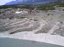
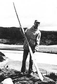
Evidence can be found both for the tidal wave along the Alsek lower reaches and for the reservoir on the upper reaches. Stair-shaped steps - caused by the waves of the lake, driftwood banks along the former shoreline - datable with the C14 method, sand dunes from the sediment deposits on the lake bed at that time and boulders that were transported by the glacier. Clague and Rampton found the 2 meter long, broken piece of a carved paddle high above the Alsek during their field research in 1981.
Current situation
Changes in the hydrological conditions at the bottom of the glacier - possibly a consequence of global warming - have recently repeatedly led to galloping glaciers , a sudden increase in flow velocity. The result is a rapid advance of the glacier tongue, which could also cause a reservoir to form. Glacier activity takes place every 10 to 20 years, at ever shorter intervals. The last critical situation was in 2009, after which the Yukon Geological Survey installed a measuring station, a time-lapse camera and a webcam that enable permanent monitoring and documentation, even though the area is largely uninhabited. Fifty kilometers downriver, at Turnback Canyon , a second glacier, the Tweedsmuir , left the Alsek River only a narrow crevice in 2009.
literature
- F. De Laguna: Under Mount Saint Elias, The History and culture of the Yakutat Tlingit , 1972.
Web links
- Yukon Geological Survey: Lowell Glacier (English)
- Jeffrey Bond: The Little Ice Age Flooding of Haines Junction , 2008 (PDF, 14.7 MB)
Individual evidence
- ^ F. De Laguna: Under Mount Saint Elias, The History and culture of the Yakutat Tlingit , 1972.
- ^ A. Bevington and L. Copland, Characteristics of the last five surges of Lowell Glacier, Yukon, Canada, since 1948 , Journal of Glaciology, 2014
- ↑ JJ Clague and VN Rampton, Neoglacial Lake Alsek , Canadian Journal of Earth Sciences, Vol. 19, Issue 1, pp. 94-117, 1982.
- ^ Yukon Geological Survey: Lowell Glacier Extent
- ↑ Webcam images


