Newfoundland and Labrador Census Division No. 9
| Division No. 9 | |
|---|---|
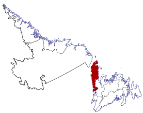
 Location of the region in Newfoundland and Labrador
|
|
| Basic data | |
| Country | Canada |
| province |
Newfoundland and Labrador
|
| Coordinates : | 50 ° 20 ′ N , 57 ° 32 ′ W |
| Residents | 15,607 (as of 2016) |
| surface | 13,527.12 km² |
| Population density | 1.2 inhabitants / km² |
| Time zone : | Newfoundland Standard Time (UTC − 3: 30) |
The Census Division No. 9 is an administrative unit in the Canadian province of Newfoundland and Labrador .
The Census Division No. 9 is located in the northwest of the island of Newfoundland and extends over the Great Northern Peninsula and the adjacent south. It has an area of 13,527.12 km². At the 2016 census there were 15,607 residents. In the census 5 years earlier it was 16,786.
Municipalities ( Towns )
- Anchor Point
- Bellburns
- Bird Cove
- Conche
- Cook's Harbor
- Cow head
- Daniel's Harbor
- Englee
- Flower's Cove
- Glenburnie-Birchy Head-Shoal Brook
- Goose Cove East
- Hawke's Bay
- Main Brook
- Norris Point
- Parson's Pond
- Port Saunders
- Port au Choix
- Raleigh
- River of Ponds
- Rocky Harbor
- Roddickton-Bide Arm
- St. Anthony
- St. Lunaire-Griquet
- St. Pauls
- Sally's Cove
- Trout River
- Woody Point
Individual evidence
- ↑ a b c Division No. 9, 2016 Census . Statistics Canada. Retrieved October 3, 2018.