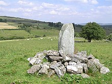
Ogham stone from Aghascrebagh
The Aghascrebagh Ogham Stone (also Aghnascribba) is one of the few Ogham stones in Northern Ireland and the only one in County Tyrone . It stands north of Carrickmore in the townland of the same name ( Irish Achadh Scriobach also Aghnascribba) near Greencastle on a pasture seven kilometers north of Creggan .
description
It is a medium-high, former menhir with a flat top and a cross-section of 45 × 50 cm. It is about 1.45 m high and tapering slightly. It has a very regular shape and is located in a low stone mound, which was probably surrounded by a collection of field stones to protect it (against grazing cattle). The inscription at the bottom of the southeast edge has been interpreted as "Tu Te Tto Maqi Maglant" (also "DOTELLO MAQI MAGLANI"), but only about six letters can still be read today. They are two names that are linked to the word Maqi, which means "son" (the early form of today's Mac). The stone was probably erected in the late Iron Age . Ogham stones are rare in Northern Ireland, but there are hundreds in the southwest of the island.
It is believed that the re-erected stone is a grave or memorial inscription that was incised around 500 AD.
The menhir
To the northwest, a few hundred meters away, is a 2.4 m high, 1.3 m wide and 0.5 m high menhir ( English standing stone ). It's one of the most impressive in County Tyrone.
literature
- Damien McManus: A Guide to Ogam. To Sagart, Maynooth 1991, ISBN 1-870684-17-6 .
- Charles Thomas: And Shall These Mute Stones Speak? University of Wales Press, Cardiff 1994, ISBN 0-7083-1160-1 .
- Sabine Ziegler: The language of the old Irish Ogam inscriptions. Vandenhoeck & Ruprecht, Göttingen 1994, ISBN 3-525-26225-6 .
Web links
Individual evidence
- ↑ Coordinates of the Ogham: 54 ° 41 ′ 56.6 ″ N , 7 ° 2 ′ 31 ″ W
- ↑ Coordinates of the menhir: 54 ° 42 ′ 0.3 ″ N , 7 ° 2 ′ 33.5 ″ W

