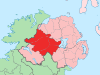
County Tyrone
| map | |
|---|---|

|
|
| Basic data | |
| Country: |
|
| Administrative headquarters: | Omagh |
| Province: | Ulster |
| Irish name: | Tír Eoghain |
| Surface: | 3,761 km² |
| Residents: | 166,516 (2001) |
Tyrone ( Irish : Tír Eoghain , "Eoghans Land") is one of six historic counties ( counties ) of Northern Ireland .
geography
In the north are the Sperrin Mountains , in the east the county is bounded by Lough Neagh . The middle of the county consists of high and hill country.
Cities
Attractions
- Aghagogan, menhir , stone box , wedge tomb
- Aghalane, Court Tomb
- Altadaven Wood , "St Patrick's Chair and Well"
- Altdrumman , Portal Tomb
- Athenree (portal tomb)
- Balix Lower , Court tomb "The white rocks"
- Ballyrenan Portal tombs
- Ballywholan , Portal tomb "Carnfadrig" and Dual Court Grave "Carnagat"
- Beaghmore , Stone Circles and Cairns
- Churchtown, "Todd's Den and Druid's Altar"
- Clady Haliday, court tomb
- Court Tomb of Garvagh , megalithic
- Cregganconroe
- Creggandevesky , Court tomb
- Knockmany , Passage Tomb "Annia's Cove"
- Celtic crosses , high crosses of Ardboe and Donaghmore [1]
- Killyliss, Rath
- Loughash and Cashelbane Wedge Tombs
- Ogham stone and menhir from Aghascrebagh
- Tullaghoge Fort , O'Neils inauguration site.
Personalities
- Brian Friel (1929-2015), playwright
- Benedict Kiely (1919–2007), writer and journalist
- Dennis Taylor (born 1949), snooker player
Web links
Commons : County Tyrone - Collection of pictures, videos, and audio files
Coordinates: 54 ° 37 ′ N , 7 ° 10 ′ W
