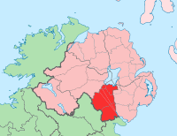
County Armagh
| map | |
|---|---|

|
|
| Basic data | |
| Country: |
|
| Administrative headquarters: | Armagh |
| Province: | Ulster |
| Irish name: | Ard Mhacha |
| Surface: | 1327 km² |
| Residents: | 141,000 (estimate) |
Armagh ( Irish : Ard Mhacha ) is one of the six historic counties (English county ) in the Northern Irish part of the island of Ireland .
geography
The county is south of Lough Neagh . The north consists of fertile plains through which the rivers Bann and Blackwater flow . In the south, a hill country extends up to a height of 550 meters.
history
In prehistoric times, megalithic systems were built in today's county . Before the 5th century, the area belonged to the Kingdom of Ulster , from which the Kingdom of Oriel emerged in the 5th century . In early Christian times, the capital of the same name became a bishopric, which is associated with St. Patrick , for which there are numerous references in the Book of Armagh .
At the end of the 12th century the area was conquered by the Anglo- Normans and came under English rule. The ruling Anglo-Norman nobility soon broke away from English rule, which only regained its strength there in the middle of the 17th century ( Oliver Cromwell ); thus the founding of the county falls at this time.
economy
Ireland's most important apple-growing region is located in the north, while sheep farming is predominant in the hilly south . There is food, clothing, furniture, and light industries.
Cities
Attractions
- Aghmakane megaliths
- Annaghmare , Court Cairn
- Ballykeel , dolmen
- Ballymacdermot , Court Cairn
- Clonlum , megalithic systems
- Clontygora , megalithic complex
- Killevy Churches
- Navan Fort
- Ráth from Corliss
- Slieve Gullion , North and South Cairn
- Stone pillar from Kilnasaggart
See also : Court tomb , also 'court cairn' (German court grave )
Web links
Coordinates: 54 ° 19 ′ N , 6 ° 33 ′ W

