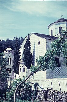
Panagia (Thasos)
Panagia ( Greek Παναγία ( f. Sg. )) Is a village in the northeast of the Greek island of Thasos . The place is located east of the Ipsarion massif at the foot of the Profiti Ilias at 1,108 m above sea level in a depression that cannot be seen from the sea and which runs southeast into the coastal plain on the wide bay of Potamia. The old town center, built around 1831 and equipped with ancient spoilage, features the Church of the Assumption of Mary ( Greek : Κοιμήσις της Παναγίας ( f. Sg. )), Which is site-specific with almost continuous slate roofing of the houses, as well as canals and fountains that are fed by strong mountain water . The island round road leading through the lower, eastern local area offers an ideal connection to Limenas in the north and to the south of the island in the direction of Aliki .
Due to the constant flow of water, extensive olive groves, fruit cultures with cherry, walnut, mulberry, carob, pomegranate, chestnut and fig trees, as well as vines and a wide variety of vegetables, thrive. Most of the inhabitants live from the well-developed package tourism. The place has developed into one of the richest villages on the island.
The town of Panagia (849 inhabitants 2001) also includes the coastal town of Skala Panagias with its hotels, restaurants and the Chrysi Ammoudia ( Greek Χρυσή Αμμουδιά ( f. Sg. )) Or Golden Beach , which is one of the best and best known because of its fine sand Beaches on the island apply.
history
The settlement was first mentioned in connection with the pirate raids in the 14th century. In view of the frequent raids by Genoese , Venetians , Lombards, Sicelians, Catalans, Ottomans, Saracens and Greek Roumelians, who invaded the island mainly from the north, the inhabitants of Limenas founded today's Panagia as a safe haven.
The place functioned for about 300 years, until the beginning of the Egyptian feudal sovereignty, as the main administrative seat of the island and was described as wealthy in 1828. Panagia was looted and set on fire in 1837 and 1838. After the final liberation from Ottoman rule , Konstandinidis Chatsi Panagia again used from around 1840/58 as the official seat of the Başçorbacı (Proedros) of Thasos. In 1856 the settlement consisted of 600 slate-roofed houses made of marble rubble stones. As the main town on the island, the seat of the Mudir and a small Ottoman military unit was located here . Panagia lost this function to Theologos, but gained it again shortly after the island was liberated from Ottoman occupation.
The doctor and connoisseur of the Thasitic antiquities, Christidis, friend of all archaeologists who traveled to the island from 1858 on, came from Panagia .
Individual evidence
- ↑ A. von Prokesch-Osten: Memoirs and memories from the Orient , Volume 3, p. 621.
- ↑ G. Perrot: Memoire de l'ile de Thasos , p. 63.
- ↑ C. Fredrich: Before the Dardanelles, on ancient Greek islands and on Mount Athos , chap. 6: Thasos , p. 128.
Coordinates: 40 ° 44 ' N , 24 ° 44' E

