Panaitan
| Panaitan | ||
|---|---|---|
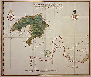
| Map by Johannes Vingboons (c. 1665–1668) | ||
| Waters | Sunda Street | |
| Geographical location | 6 ° 35 ′ S , 105 ° 13 ′ E | |
|
|
||
| length | 21 km | |
| width | 12.7 km | |
| surface | 170 km² | |
| Highest elevation | Gunung Raksa 329 m |
|
| Residents | uninhabited | |
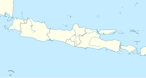
| Map of the Sunda Strait with Panaitan | ||
Panaitan, Bahasa Indonesia : Pulau Panaitan , literally translated Prinzeninsel , earlier in Dutch Prinseneiland , is the largest Indonesian island in the Sunda Strait on the edge of the Java Sea between Java and Sumatra .
The island, which is 329 m high at its highest point, is located in front of the westernmost tip of Java with the Ujung Kulon World Heritage National Park , to which it belongs. Like the nearby island of Krakatau , it is of volcanic origin. There are no known eruptions in historical times. The name Prince Island comes from the fact that it was considered the property of Javanese princes. Administratively it belongs to the administrative district Pandeglang in the province of Banten .
Panaitan did not suffer as badly from the Krakatoa eruption in 1883 as many other islands in the region, only the north and parts of the east were hit by tsunamis ; later 55 bodies were found. These included a hādj with royal logging permission and around 50 settlers.
Panaitan is hilly, covered with forest and has a rich animal life: deer, wild boar, monkeys, snakes (pythons) and birds. There are several species of freshwater crocodiles and giant lizards are found. Ancient Hindu sculptures have been found on Mount Raksaa. The coastal region offers sandy beaches and coral reefs.
literature
Simkin & Fiske: Krakatau 1883: The Volcanic Eruption & Its Effects (1983)


