Pangani (Tanzania)
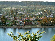
Pangani is a small town on the Tanzanian coast between Dar es Salaam and Tanga , which lies at the mouth of the Pangani River . It has about 8000 inhabitants and is the seat of the administration of the district of the same name.
The small town has a long history as a once important coastal and port city of Swahili culture . Some large Swahili houses, including the former German boma (administration building), are visible remnants of a rich past.
history
The beginnings of Pangani are in the dark. There is speculation that the site is in place of the ancient Rhapta mentioned in the Periplus of the Erythraean Sea . Archaeologists have identified remains of 15th century settlements near the city.
Under the rule of Zanzibar , Pangani experienced an upswing in the 19th century, when there was increased demand for ivory on the world market and Zanzibar increasingly imported slaves to build up its plantation economy. In the vicinity of the city sugar cane plantations were established that produced for export. Pangani also became the starting point for the caravan trade inland.
The 1888 uprising
On August 16, 1888, as part of the Zanzibari mainland, the city was to be transferred from the administration of the Sultan to that of the German-East African Society (DOAG), which had leased the coastal strip of what is now Tanzania. The DOAG representative Emil von Zelewski caused by his provocative appearance - u. a. he and his dog harassed the Liwali of Pangani in a mosque and disregarded the sultanate's flag - a spontaneous revolt of the city population, which was initially quickly suppressed by German marines. This was the trigger for the uprising of the East African coastal population against the DOAG, which extended from Pangani across the entire coast. The plantation owner and trader Buschiri bin Salim emerged as an important leader .
On July 9th, 1889, Pangani was captured by German colonial troops who, after the collapse of the DOAG's rule, conquered their territory as a colony of the German Empire.
Decline
Under the colonial rule, Pangani experienced a decline in its economic importance. Because of the upstream barre, the river estuary was only suitable for dhows , but not for modern steamers. The Germans and later the British expanded the modern port of Tanga just north of Pangani. Under German rule, however, Pangani remained the seat of a district office , had a main customs office (first class customs office), post office and telegraph station and was the location of the police force.
economy
The establishment of sisal plantations brought a certain vitality to the place. In the 1990s, the natural beaches at Pangani were rediscovered as tourist destinations. The number of visitors is limited due to the poor infrastructure. To date (2006) there is no asphalt road in the entire Pangani district.
literature
- Heinrich Schnee (Ed.): German Colonial Lexicon . Leipzig 1920, volume 3, p. 10f.
- Cornelia Pieroth: Pangani during the German colonial era , Frankfurt a. M. 2014.
- Cornelia Pieroth: Pangani. On the trail of a German colonial city . In: Stefan Noack / Christine de Gemeaux / Uwe Puschner (eds.): German East Africa. Dynamics of European cultural contacts and horizons of experience in the colonial area , Berlin a. a .: Peter Lang 2019 (Civilizations & History; 57), ISBN 978-3-631-77497-7 , pp. 39–58.
Web links
Coordinates: 5 ° 24 ' S , 38 ° 59' E
- Image documentation of historical Pangani, 2018


