
Pantocrator (mountain)
| Pantocrator | ||
|---|---|---|
 |
||
| height | 906 m | |
| location | Corfu , Greece | |
| Coordinates | 39 ° 44 '54 " N , 19 ° 52' 19" E | |
|
||

The Pantokrator ( Greek Παντοκράτορας ) is the highest mountain on the Greek island of Corfu . It is located in the northeast of the island. Its altitude values vary between 906 and 917 m. The name means something like ruler of all . The Venetians called the Pantocrator "Monte San Salvatore".
From the summit, to which an asphalt road leads, there is a wide view of Albania and mainland Greece when the weather is clear . There is also a 17th century monastery there , which is inhabited during the summer months. The Greek Orthodox Church is freely accessible during the day.
A striking structure on the summit is the transmission tower, a free-standing steel framework construction. There is a well below the tower.
history
- In the 5th century the mountain was the scene of violent civil wars .
- In 1374 a monastery was built on the summit, which was destroyed at the beginning of the 16th century during the Turkish siege and rebuilt in 1689 by the inhabitants of the surrounding villages.
photos

Northeast side
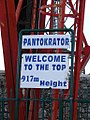
Shield on the summit
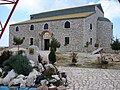
Church on the summit

Gate of the monastery grounds on the summit - inside

Summit panorama to the east


