Przemyśler Land
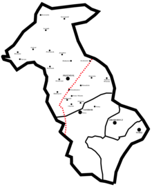
The Przemyśler Land (Polish Ziemia przemyska ) was an administrative unit of the Polish-Lithuanian aristocratic republic in the Ruthenian Voivodeship from 1434 to 1772. The main town was Przemyśl .
It comprised the powiat (circles)
- Powiat Przemyśl ( Powiat przemyski ), main town Przemyśl
- Powiat Sambor ( Powiat samborski ), main town Sambor
- Powiat Drohobycz ( Powiat drohobycki ), main town Drohobycz
- Powiat Stryj ( Powiat stryjski ), main town Stryj
In 1676 the Przemysl region had 32 towns and 980 villages.
literature
- K. Przyboś: Granice Ziemi Przemyskiej w czasach nowożytnych XVI – XVIII w. ( The borders of the Przemyśl country from the 16th to the 18th centuries ), Przemyśl 1993.
- K. Arłamowski, u. a. (Ed.): Lustracja województwa ruskiego 1661–1665 ( Ruthenian Voivodeship 1661–1665 ), Vol. 1: Ziemia przemyska i sanocka ( Przemyśler and Sanoker Land ). Wrocław, Warszawa, Kraków 1970.

