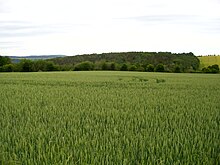
Rabenau Forest
The Rabenauer Forest is an approximately 0.79 km² forest area in the Eastern Ore Mountains . It lies on the territory of the western town of the same name, Rabenau . Adjacent villages are Oelsa in the south and Obernaundorf in the west. It is between 230 m above sea level. NHN and 274 m above sea level NHN .
Responsibility lies with the Forestry Office in Bärenfels , owned by the Free State of Saxony.
history
The Margrave of Meißen Georg Duke of Saxony entrusted Sigmund von Miltitz with the "forest" in 1454. On Matthias Öder's maps from 1586/1607 it is again referred to as "Forst". The height measurement point at the junction of Jagdflügel / Aisle 26 on the Berlin miles sheets, which is 350 m above sea level , is called the badger's den . NHN measures. In the year 1866 the forest of the Rabenauer Revier is mentioned in the Saxon village newspaper.
Waters
The Forstgrabenbach, which rises in the "Jungfer-Matzen-Born" and flows into the Oelsabach, runs through the forest near Rabenau. The Oelsabach flows in sections through the forest near Oelsa to Rabenau. The Geßlichbach flows on the southern edge through the valley of the same name, where it represents the natural border to the adjacent forest, the Kohlung and the Thürmersleite - also called Dörner Leite - near Oelsa.
ways
The White Road runs from the Marktsteig near Rabenau through the forest, where it crosses the fighter wing, to the Oelsa State Road. The fighter wing goes from the northeast to the southwest edge of the heath, where it crosses the White Road and the aisles 27/26. The Lindenwehrweg begins on the White Road and goes along the edge of the forest on the Geßlichbach to the Black Pond. The Mühlsteig, which goes from the former Spechtritzer mill via Kleinoelsa in the Geßlichgrund into the heath, used to run to the Marktsteig and ends today on the Lindenwehrweg.
