Reutemattensee
| Reutemattensee | ||
|---|---|---|

|
||
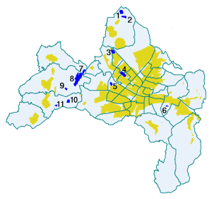
| Location of the Reutemattensee (11) in the urban district of Freiburg | ||
| Geographical location | Baden-Württemberg | |
| Data | ||
| Coordinates | 47 ° 58 '54 " N , 7 ° 43' 46" E | |
|
|
||
| Maximum depth | 2 m | |
The Reutemattensee is located in the Freiburg district of Tiengen and is also known as Tiengener See . The maximum 2 meter deep quarry pond was built in 1969/70 and was originally supposed to be enlarged to 20-25 hectares. Its gravel was used for the vineyards on the Tuniberg. It used to be used as a bathing lake, but is now heavily weed in summer . In 1973, the Kuhlagerbächle was briefly discharged into the lake, but this did not lead to any improvement in the water quality due to the entry of mud and leaves. It is still fed by groundwater. It was feared that the lake would tip over, but further research invalidated this. Today the Reutemattensee is only used as a fishing water; Occurring fish species are pike, carp and tench, which lay their spawn on the plants and whose young can hide well there.
Individual evidence
- ↑ Water town plan of the city of Freiburg
- ↑ The lake is far too quiet . Badische Zeitung, December 23, 2008
- ^ Freiburg Tuniberg: Surprise in Tiengen: Reutemattensee is intact - badische-zeitung.de. Retrieved September 9, 2013 .

