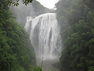
Ryūmon waterfall
| Ryūmon waterfall | ||
|---|---|---|
| Coordinates | 31 ° 45 ′ 9 ″ N , 130 ° 40 ′ 7 ″ E | |
|
|
||
| place | Aira , Kagoshima Prefecture , Japan | |
| height | 46 m | |
| width | 43 m | |
| flow | Amikake → Kagoshima Bay | |
The Ryūmon Waterfall ( Japanese 龍門 滝 , Ryūmon-daki ) is a waterfall in Kagoshima Prefecture . It has a fall height of 46 m and a width of 43 m and is part of the list of the top 100 waterfalls in Japan drawn up by the Ministry of the Environment in 1990 . The amount of water fluctuates depending on the season, as water is taken from the inflow for agriculture. The water masses are therefore lowest in the period from the end of May to September.
See also
Web links
- Ryūmon Waterfall Information (Japanese)

