Sachsenbrücke (Leipzig)
Coordinates: 51 ° 19 ′ 49 ″ N , 12 ° 21 ′ 15 ″ E
| Sachsenbrücke | ||
|---|---|---|
| use | footbridge | |
| Crossing of | Magpie flood bed | |
| place | Leipzig | |
| construction | Reinforced concrete bridge | |
| completion | 1928 | |
| location | ||
|
|
||
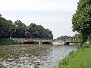
The Sachsenbrücke over the Elster flood bed connects the eastern and western parts of the Clara-Zetkin-Park (formerly König-Albert-Park ) in Leipzig . Located southwest of the city center, it also provides a car-free connection from the center to the west of Leipzig with Anton-Bruckner-Allee for pedestrians and cyclists.
history
The bridge was given its name in memory of the change of side of the Saxon troops from Napoleon Bonaparte to the allies during the Battle of Leipzig in 1813. However, this name only became official on November 7, 1901.
The first structure at the same location was built in 1897 for the Saxon-Thuringian industrial and commercial exhibition . The bridge in its current design was built in 1928 after the Elster flood bed was widened.
Today the cultural monument is a popular meeting place, especially for young people from Leipzig, and it also attracts musicians and artists, especially in summer.
literature
- Bettina Weil: Leipziger Brücken II - Bridges over the White Elster, Elsterflutbett, Elsterbecken, Elstermühlgraben, Hundewasser and Knauthainer Elstermühlgraben [10/08]: City of Leipzig, Office for Statistics and Elections, Leipzig 2008, pp. 48–49.
Web links
Individual evidence
- ↑ Because 2008
- ↑ Monument ID: 09262690
- ↑ leipzig-leben.de. Retrieved September 24, 2014 .

