Santa Clara (island)
| Santa Clara | |
|---|---|
| Satellite image, Santa Clara is on the lower left | |
| Waters | Pacific Ocean |
| Archipelago | Juan Fernández Islands |
| Geographical location | 33 ° 42 ′ 25 ″ S , 78 ° 56 ′ 39 ″ W |
| length | 3.5 km |
| width | 1.3 km |
| surface | 2.2 km² |
| Highest elevation | 375 m |
| Residents | uninhabited |
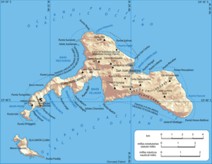
| Map, Santa Clara is on the lower left | |
The island of Santa Clara ( Spanish : Isla Santa Clara ) is the smaller third island in the group of the Juan Fernández Islands in the Pacific Ocean . The archipelago belongs politically to Chile and is administratively assigned to the Chilean V Region ( Región de Valparaíso ).
About 1.5 kilometers south of the western tip of Robinson Crusoe Island located Eiland km² with an area of around 2.2 uninhabited. The highest point of Isla Santa Clara is 375 m above sea level.

