Shabwat
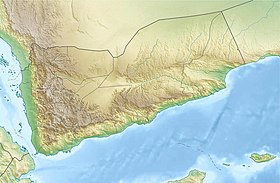
Shabwat in what is now Yemen |
Shabwat ( old South Arabic s 2 bwt S 2 abwat, Arabic شبوة Shabwa , DMG Šabwa , Greek Σάββαθα , Latin Sabbatha ) was the capital of the old South Arabian empire Hadramaut until the 4th century AD. It was located in the area of today's town of Shabwa , on the eastern edge of the Ramlat es-Sayhad desertin present-day Yemen, about 300 km east-northeast of Sana'a , at the exit of Wadi Ma'schar into the desert at about 850 m above sea level. Its importance stemmed from the fact that it had salt pits and thus a key position on the old incense routetook. Since 1975 the ruins have been studied by French archaeologists.
history
During an excavation in the southeast, in the area of building 41, carried out in 1976–1981, a stratigraphic sequence was found. According to the radiocarbon dating from the 16th century BC, the 14 layers found in the process range from BC until shortly after the final destruction by Himyar in the 4th century AD. It is noticeable that between stratum III (around 1300 BC) and stratum V (according to imported ceramics: 6th century BC) there is only one stratum, which speaks against a continuity of settlement from the Bronze Age to the historical period. The heyday of Shabwat falls in stratum VI to IX (6th century BC to 2nd century AD). In the 3rd century AD, Shabwat was conquered by Saba .
construction
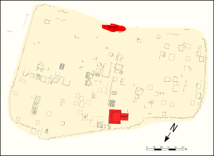
The ruins of ancient Shabwat consist of an outer and an inner city. The outer city has a north-south extension of at least one kilometer and a maximum east-west extension of about 900 m. The inner city in the south has a southwest-northeast extension of about 500 m and a maximum northwest-southeast extension of 365 m. The outer city wall, which was partially destroyed by the wadi, was at least 3.35 km long, the inner approx. 1.53 km. The inner city covered an area of approx. 0.15 km².
Inner city

The inner city was cut in the middle by a north-south road, which began at the north-west gate, the largest gate in the city. Behind the gate it opened in the east into an approx. 1600 m² large square, which was opposite the Royal Palace on the other side of the street. The main street ended in an important, but poorly preserved temple complex on the southern edge. How the rest of the road network was connected to the main road cannot be clearly determined, although the side roads were obviously oriented at right angles or parallel to it, but only a few branches are secured. Gardens and smaller courtyards have also been preserved as further open spaces in addition to streets and public spaces. Most of the buildings had a simple rectangular floor plan and a floor area of at least 100 m². Some buildings stand out for their size and complex floor plan, they were probably reserved for the upper class.
Outdoor areas
The outer city, i.e. H. the area between the two city walls was never really populated. The only significant buildings in this area are a temple in the southwest (building no. 114) and the citadel of al-Chajar in the southeast.
Outside the fortifications, some brick buildings were excavated in 1987.
See also
literature
- (Various authors): Fouilles de Shabwa , in: Syria. Revue d'art oriental et d'archéologie , Tome 68, Fasc. 1-4. Geuthner, Paris 1991 pp. 1-462
- Paul Yule : Himyar. Late Antique in Yemen / Late Antique Yemen. Linden Soft Verlag, Aichwald 2007, ISBN 978-3-929290-35-6 .
- Wendell Phillips, Kataba and Saba. Discovery of the lost kingdoms on the biblical spice routes of Arabia. S. Fischer Verlag, Berlin et al. 1955.
Individual evidence
- ↑ Ptolemy Geographia 06/07/38
- ↑ Pliny the Elder Naturalis historia 6.32.38
- ↑ Wendell Phillips, Kataba and Saba. Discovery of the lost kingdoms on the biblical spice routes of Arabia, p. 36 (see lit.)
- ^ Paul Yule, p. 125 f. (see lit.)
Coordinates: 15 ° 22 ' N , 47 ° 1' E


