Bay of Pigs
| Bay of Pigs, Playa de Girón |
|
|---|---|
|
View over Playa Larga in the Bay of Pigs |
|
| Waters | Gulf of Cazones , Caribbean Sea |
| Land mass | Cuba (island) |
| Geographical location | 22 ° 16 ′ N , 81 ° 12 ′ W |
| width | 14 km |
| depth | 45 km |
| surface | 168 km² |
| Tributaries | Zanja la Puente |
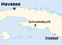
The Bay of Pigs (Spanish Bahía de Cochinos ) with the beaches of Playa Girón and Playa Larga is a bay on the south coast of Cuba in the area of the municipality ( município ) Ciénaga de Zapata . It forms the eastern boundary of the Zapata Peninsula .
The name is not derived from pigs (Spanish: cochinos ), but from Caribbean triggerfish , which are also called cochinos in Cuba .
invasion
Between 17 and 19 April 1961 here a failed CIA -assisted invasion by Cuban exiles against the government of Fidel Castro . The invasion marked the first climax of US anti-Cuban actions .
The UN Security Council debated the legality of the attack. However, Cuba failed with its application to condemn the USA as an aggressor because of the United States' right of veto .
Web links
Individual evidence
- ↑ Cuban Information Archives (English)

