Spurn Point Military Railway
|
|
|
|---|---|
|
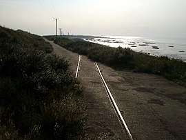
Track remains of the Spurn Point Military Railway
| |
| Route length: | 6 km |
| Gauge : | 1435 mm ( standard gauge ) |
The Spurn Point Military Railway was a 6 km long standard gauge , mainly used by the military railway line from Kilnsea to Spurn Point in East Riding of Yorkshire on Humber - estuary in England.
Opening and use
Spurn Point, a constantly shifting headland made of sand and scree, was used for military purposes in 1805 during the Napoleonic Wars (1803-1815). Immediately after the declaration of World War I , the number of troops at Spurn Point was increased significantly. The British War Department decided to build a railway line from Kilnsea to Spurn Point to secure supplies.
The railway line was operated by CJ Wills & Company using rails and other recycled materials left over from the construction of the Great Central Railway . It opened in 1915 after the rails reached the pier at Spurn Point. Supplies unloaded from boats there could be brought by rail to the defensive positions along the route, as there were only narrow and winding roads in the area.
Most of the trains were pulled by small locomotives. There were diesel and gasoline rail buses , especially after the only permanent locomotive manufactured by the Vulcan Foundry, Kenyon, was scrapped in 1929.
The railway line was not connected to other lines on the mainland and had no train stations. The local population used self-built sailing lorries to drive on the route, which led to derailments and accidents with oncoming rail vehicles. An Italia racing car that had been converted into a rail vehicle and capable of speeds of 100 km / h was used on the route. Cannons were also transported over the route, whereby the train stopped once at the narrowest point of the headland and the train was washed almost on one side by the Humber and on the other side by the North Sea.
Shutdown
The line was decommissioned in the post-war period of World War II in 1951 and replaced by a road. Spurn Head was gradually demilitarized from 1956 to 1959. Apart from a few remains of track, only a few remains of the railway line have survived today.
further reading
- Kenneth E. Hartley, Howard M. Frost [1976]: The Spurn Head Railway . Lunart Productions, Withernsea 1981, ISBN 0 906 971 05 5 .
- John Scott-Morgan: British Independent Light Railways . David and Charles, Newton Abbot in 1980, ISBN 0 7153 7933 X .
Web links
Remarks
- ↑ Also known as the Spurn Head Railway or Spurn to Kilnsea Railway .
Individual evidence
- ^ A b Ronald Redman: Railway Byways in Yorkshire . Dalesman Books, Clapham 1979, ISBN 0852065566 , p. 69.
- ^ Spurn and its railway . Retrieved November 16, 2016.
- ^ The line on an interactive rail map . Retrieved December 18, 2016.
- ↑ World War One: Spurn Point's military relics at sea's mercy . In: BBC News , February 28, 2014. Retrieved February 24, 2016.
- ^ Spurn Railway . Retrieved February 24, 2016.
- ↑ a b Historic England. "Spurn Point Military Railway (931916)". Retrieved February 23, 2016
- ↑ Chris Bates: The Spurn Head Railway . In: Martin Bairstow (Ed.): Railways in East Yorkshire Volume 3 . Bairstow, Farsley 2007, ISBN 1-871944-32-5 , p. 70.
- ^ Robert Duck: On The Edge - Coastlines of Britain . Edinburgh University Press, Edinburgh 2015, ISBN 9780748697625 , pp. 168-169.
- ^ Spurn Head Railway , Band Railway Magazine. Volume LXXXVI, No. 522 December 1940, December 1940, pp 654-655.
- ^ Spurn Head Railway , Band Railway Magazine. Volume 88, No. 540, December 1942, p. 200.
- ↑ a b Wind power? It's a thing of the past! . In: Hull Daily Mail , March 1, 2010. Retrieved on February 24, 2016. ( Page no longer available , search in web archives ) Info: The link was automatically marked as broken. Please check the link according to the instructions and then remove this notice.
- ↑ Leslie Thomas: Spurn Head . December 2013. Retrieved February 25, 2016.
- ↑ Spurn national nature reserve; new wildlife visitors center . S. 42. December 16, 2015. Archived from the original on February 11, 2017. Info: The archive link was inserted automatically and has not yet been checked. Please check the original and archive link according to the instructions and then remove this notice. Retrieved February 25, 2016.
Coordinates: 52 ° 51 '34.9 " N , 4 ° 6' 58.6" W.

