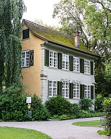
Stadtgarten (Winterthur)
The Stadtgarten is a city park in the center of Winterthur . It extends over an area of 22,743 m² and is located right next to the old town and is the most centrally located park in the city.
location
The city garden is part of the green belt that surrounds the historic center of Winterthur. It is located north of the historic old town between Stadthausstrasse and Museumsstrasse - although it only extends to Stadthausstrasse at one point . Elsewhere between Stadtgarten and Stadthausstrasse are the Oskar Reinhart Museum and the Summer Theater . On the west side the park is closed by Merkurplatz and on the east side the park extends to the old town schoolhouse .
construction
The park itself is criss-crossed by gravel paths and, in addition to wide lawns, is loosely planted with trees and flower beds. Only towards Museumstrasse is there a deliberate delimitation from the street with thicker planting. Some rarer tree species grow in the park, such as sequoias , a slit-leaved beech , a sugar maple and a rare horse chestnut . The central design element in the park is a water basin that is located behind the Oskar Reinhart Museum when viewed from the old town. Another striking feature is the Haus zum Balustergarten , also known as the “baroque house”, which separates a smaller part of the park from the rest. A playground is also part of the city park.
history
Until the end of the 19th century, the city garden was used by wealthier citizens of the city for their private gardens. The Balustergarten house , which was built in 1740 and is still in the middle of the city park, dates from this time .
In 1898 the city of Winterthur acquired the first part of today's city park, the Sulzergarten, and created a bush garden on it. In 1902 the first new garden was built according to the plans of the garden architects Gebrüder Mertens , from then on the new plant got the name Stadtgarten by the population. The city garden remained in this form for the next few years. During the cultivation battle of the Second World War, the city garden was also used as a potato and vegetable field.
After the end of the Second World War, the city expanded the previously existing city garden to Merkurstrasse in 1946 with the Strauss, Rheinfels and Merz-Rieter-Gut plots, thus reaching its current size. Then an ideas competition was launched and Walter Leder's winning project was implemented by 1951.
Web links
Coordinates: 47 ° 30 '3.3 " N , 8 ° 43' 41.7" E ; CH1903: 697,164 / 261926


