Tabarca (island)
| Tabarca (Plana) | ||
|---|---|---|
| Aerial view of Tabarca and the offshore islands | ||
| Waters | Mediterranean Sea | |
| Geographical location | 38 ° 9 '59 " N , 0 ° 28' 27" W | |
|
|
||
| length | 1.8 km | |
| width | 380 m | |
| surface | 30 ha | |
| Highest elevation | 15 m | |
| Residents | 55 (as of 2015) 183 inhabitants / km² |
|
| main place | Tabarca | |
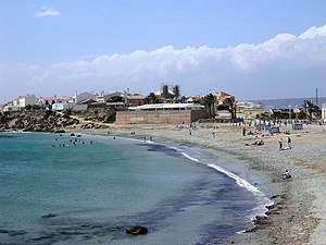
| Playa Grande beach | ||
The island of Tabarca is located in the Mediterranean Sea near the Cape of Santa Pola near Alicante , from which it is around 5 km away. It is administered from Alicante, which is around 20 km north of the island. It is the only inhabited island in the Comunidad Valenciana .
The island is 1800 meters long and about 380 meters wide. Near the main island there are three smaller secondary islands , Cantera in the west, Nau in the east and Galera in the south. Cantera in the west of the island ( la cantera = 'the quarry') only became an island through rock mining , which is separated by a shallow stretch of sea.
The number of inhabitants is declining, in 2003 there were 135 inhabitants on the island, in 2009 it was 73, in 2015 it was 55.
The island was probably called Planesia by the Greeks, then Planaria by the Romans. In 1768 mainly Genoese prisoners came here from the Tunisian island of Tabarka and from King Charles III. were saved. He ordered a part of the island to be dammed up where the people should live. The island was therefore called Nueva Tabarka or today only Tabarca .
The main source of income for the islanders is tourism . The island is mostly visited in the summer when day trips are made from Alicante or Santa Pola.


