Tahkuranna
| Tahkuranna | |||
|
|||
| State : |
|
||
| Circle : |
|
||
| Coordinates : | 58 ° 14 ' N , 24 ° 30' E | ||
| Area : | 103.4 km² | ||
| Residents : | 2.010 (01.2006) | ||
| Population density : | 19 inhabitants per km² | ||
| Time zone : | EET (UTC + 2) | ||
| Community type: | former rural community | ||

|
|||
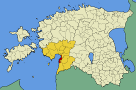
Tahkuranna (German: Tackerort ) is a former rural community in the Estonian district of Pärnu with an area of 103.4 km². In 2017 Tahkuranna was incorporated into the rural community of Häädemeeste .
Tahkuranna was about 46 km south of Pärnu . The rural community had inhabitants in 2010 (as of January 1, 2006). In addition to the main town Võiste, which was first mentioned in 1601, it included the villages of Laadi, Leina , Lepaküla, Mereküla, Metsaküla, Piirumi, Reiu, Tahkuranna and Uulu .
The long sandy beach on the Gulf of Riga was impressive . The economy has traditionally been focused on fishing and forestry.
Tahkuranna is the birthplace of the first Estonian President Konstantin Päts , to whom a memorial today commemorates.

