Tidal channel
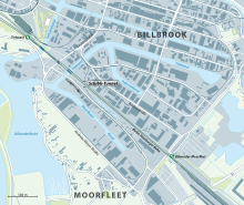
The Tidekanal is a canal in the Hamburg district of Billbrook . It is 2600 meters long and 70 meters wide throughout. The canal serves to develop the easternmost part of the Billbrook / Rothenburgsort industrial area.
The canal branches off from the Moorfleeter Canal in a north-easterly direction ( Lage ). After 200 meters it crosses under the Halskebrücke, after another 80 meters the Berlin – Hamburg line and the Hamburg S-Bahn line to Bergedorf . After 280 meters, the third canal crossing comes with the Bredow Bridge. Then begins a curve that brings the canal in an east-southeast direction. At the apex of the curve, after a total of 980 meters, the industrial canal branches off to the south. The canal then runs 1620 meters parallel to the Billbrook Canal to the north , to which there is no connection, and passes under the Tide Canal Bridge, over which the Moorfleeter Strasse runs. The tidal channel ends in a turning basin ( position ).
The Moorfleeter Canal is a state waterway and is part of the port usage area of the Port of Hamburg . It is part of the tidal harbor and falls dry during the low tide from the turning basin to the Bredow bridge.
Web links
proof
- ↑ Geoportal Hamburg , accessed on April 5, 2019
- ↑ Hamburg Water Act (HWaG) in the version of March 29, 2005 , accessed on April 14, 2019
- ↑ Port Development Act of January 25, 1982, Annex 2: Description of boundaries , accessed on April 5, 2019

