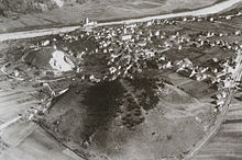
Toma hill
A Tomahügel is an isolated hill -shaped accumulation of rock debris in a plane. Albrecht Penck and Eduard Brückner introduced the term Toma landscape in 1901. It is derived from the Surselvian word Tuma ( German hill), based on a series of such characteristic elevations, the Tumas , in a section of the Alpine Rhine Valley between Chur and Domat / Ems . According to the Swiss geologist Adrian Pfiffner, the term Tomahügel should be replaced by Tuma according to the type locality .
Toma mounds typically have a very regular, symmetrical shape. According to Gerhard Abele's definition (1969), a toma hill usually contains a core of landslide material , but usually also boulders. An earlier assignment to ice age processes has now been refuted (u. Av Poschinger & Ruegg 2012). The emergence of erosion from a larger landslide area has also been refuted (G. Abele 1969), since the tumas in the vicinity of the probably responsible Flims landslide are not connected underground.
An area with several such elevations is referred to as a Toma landscape, and in Switzerland also as a Tuma landscape.
swell
- Gerhard Abele: Rockslide landscapes formed by ice . In: Zeitschrift für Geomorphologie , Suppl. 8, pp. 119–147, Berlin 1969.
- H. Brunner: The Chur Toma . In: Bündner Jb. , 4:67, 1962, pp. 67-75.
- Av Poschinger, Th. Ruegg: The Chur Tomahügel, a special testimony to the genesis of the landscape . In: Annual report of the Naturforschenden Gesellschaft Graubünden , 117, 2012, pp. 93–100.
supporting documents
- ^ Albrecht Penck, Eduard Brückner: The Alps in the Ice Age . 3 volumes, Leipzig 1901/09.

