Urvich Wall
| Urvich Wall | ||
|---|---|---|
|
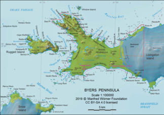
Map of the Byers Peninsula ( Livingston Island ) with the Urvich Wall (right of center) |
||
| location | Livingston Island , South Shetland Islands | |
|
|
||
| Coordinates | 62 ° 39 ′ S , 60 ° 58 ′ W | |
The Urvich Wall (English; Bulgarian Урвичка стена Urwitschka stena ) is a narrow, crescent-shaped, non-icy , north-south orientation 6.7 km long, 400 m wide and up to 121 m high mountain ridge on the Livingston Island in the southern archipelago Shetland Islands . It represents the border between the Byers Peninsula in the west and the Rotch Dome in the east.
Spanish scientists mapped it in 1992, Bulgarian in 2009. The Bulgarian Commission for Antarctic Geographical Names named it in 2006 after the medieval Urvich fortress in the outskirts of the Bulgarian capital Sofia .
Web links
- Urvich Wall at the Australian Antarctic Data Center (English)

