Vanderlin Island
| Vanderlin Island | ||
|---|---|---|
| Landsat image of Vanderlin Island | ||
| Waters | Gulf of Carpentaria | |
| Archipelago | Sir Edward Pellew Islands | |
| Geographical location | 15 ° 43 ′ S , 137 ° 1 ′ E | |
|
|
||
| length | 30 km | |
| width | 11 km | |
| surface | 264 km² | |
| Highest elevation | 87 m | |
| Residents | around 20 <1 inh / km² |
|
| main place | Uguie | |
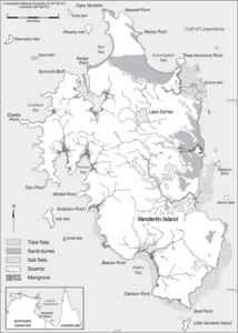
| Sketch map of Vanderlin Island | ||
Vanderlin Iceland is the largest island of the Sir Edward Pellew Group of Islands . The archipelago is located in the Northern Territory of Australia .
geography
The island is rocky and very rugged.
The only settlements are four family outstations on the west coast, from north to south:
![]() Map with all coordinates: OSM | WikiMap
Map with all coordinates: OSM | WikiMap
- ⊙ Mooloowa (on Base Bay), 5 residents
- ⊙ Babungi, 6 residents
- ⊙ Yulbara (one kilometer inland), population unknown
- ⊙ Uguie (south of Stokes Bay), population unknown
literature
- Robin Sim, Lynley A. Wallis: Northern Australian Offshore Island Use During The Holocene: The Archeology of Vanderlin Island, Sir Edward Pellew Group, Gulf of Carpentaria. In: Australian ARCHAEOLOGY. No. 67, December 2008, pp. 95-102 ( flinders.edu.au PDF).


