Varbla
| Varbla | |||
|
|||
| State : |
|
||
| Circle : |
|
||
| Coordinates : | 58 ° 26 ' N , 23 ° 46' E | ||
| Area : | 314 km² | ||
| Residents : | 1,013 (01.2006) | ||
| Population density : | 3 inhabitants per km² | ||
| Time zone : | EET (UTC + 2) | ||
| Website : | |||

|
|||
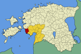
Varbla (German: Werpel ) is an Estonian rural community in Pärnu County with an area of 314 km². It is located on the Gulf of Riga , about 70 km from Pärnu .
It has 1013 inhabitants (as of January 1, 2006). In addition to the main town Varbla (151 inhabitants), it includes the villages Allika, Aruküla, Helmküla, Haapsi, Hõbesalu, Kadaka, Kanamardi, Kidise, Kilgi, Koeri, Korju, Kulli, Käru, Maade, Matsi, Mereäärse, Muriste, Mõtsu, Mäliküla, Nõmme, Paadrema, Paatsalu, Piha, Raespa, Raheste, Rannaküla, Rauksi, Rädi, Saare, Saulepi, Selja, Sookalda, Tamba, Tiilima, Tõusi, Täpsi, Vaiste, Õhu and Ännikse.
57% of the area is covered by forest, of which 42% are state-owned. The main branches of the economy are agriculture and tourism. The over 30 km long sandy beach on the Baltic Sea attracts many visitors in summer. The Art Nouveau manor house built by Eduard Kleisel in 1912 is worth seeing .
Web links
- Varbla website (Estonian)


