Viereckschanze Oberjettingen
The Celtic Viereckschanze Oberjettingen is a Celtic fortification from the time between 200 BC. BC and 50 BC It can therefore be assigned to the late Latène period within the Iron Age . The area of the ski jump is a ground monument according to the Baden-Württemberg Monument Protection Act .
It served to protect a small Celtic settlement. Contrary to what was often assumed in the past, Viereckschanzen were not just places of worship. In some Viereckschanzen references to ritual acts were found (well-like pits with offerings), but they primarily served as a protected place to live and work. A large number of these traces of Celtic settlement can be found in Bavaria and Baden-Württemberg in particular.
location
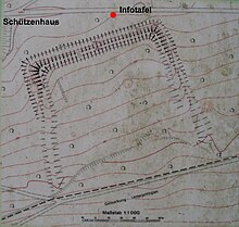
It is located about 500 meters southwest of Oberjettingen , close to the B28 at the sports area. The path between the sports field and the Schützenhaus leads after about 100 meters to the information board, from where you can see the north wall of the ski jump.
description
Celtic square entrenchments are rectangular, often square ramparts with a surrounding ditch, the corners are usually a little raised. The north wall of this jump is 95 meters long, so the jump will have covered an area of about one hectare.
The wall on the north side is very well preserved. The trench is up to 80 cm deeper than the ground level, the wall is 1.2 to 1.4 meters high measured from the inside, at the two corners in the northeast and in the northwest it is 1.7 and 2 meters respectively.
Wall and ditch look pretty flat today. Measured horizontally from the inner edge of the wall to the outside of the ditch, it is almost 10 meters. Assuming an original slope angle of 45 degrees, the bottom of the trench was 6 meters below the crest of the wall.
The wall on the west side flattens out after about 15 meters, the moat is visible 25 meters away, on the east side it is similar. The south side is in an agricultural area and has completely disappeared.
Individual evidence
- ^ Johannes Lehmann: Teutates & Konsorten, Reise zu den Kelten in Südwestdeutschland. Silberburg-Verlag, Tübingen 2006, ISBN 978-3-87407-693-7 , p. 119
- ↑ Gerhard Herm: The Celts. Econ-Verlag, Düsseldorf 1975, ISBN 3 430 144531 , p. 246 ff.
literature
- Werner Brenner: Celtic and Roman destinations in the country. Silberburg-Verlag, Tübingen 2012, ISBN 978-3-8425-1176-7
- Editing of the Time-Life books: The Celts - Europe's people of the Iron Age. Time-Life-Books BV 1995, ISBN 90-5390-526-X
- Dr. Peter Krön: The Celts in Central Europe, Salzburg State Exhibition 1980 in the Celtic Museum Hallein, Austria, Office of the Salzburg State Government, Salzburg 1980
Web links
- Web links for the Latène time at www.archaeologie-online.de
Coordinates: 48 ° 34 ′ 6 " N , 8 ° 45 ′ 45.7" E


