Waxenberg (Dunkelsteinerwald)
| Waxenberg | ||
|---|---|---|
|
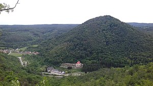
The Waxenberg photographed from Göttweig Abbey |
||
| height | 500 m above sea level A. | |
| location | Lower Austria , Austria | |
| Mountains | Dunkelsteinerwald | |
| Coordinates | 48 ° 21 '32 " N , 15 ° 36' 7" E | |
|
|
||
The Waxenberg is 500 m above sea level. A. high mountain in the Lower Austrian municipality of Paudorf . It is located about one kilometer southwest of Göttweig Abbey on the northeastern edge of the Dunkelsteinerwald and is accessible via hiking trails.
Individual evidence
- ↑ Marked hiking trails in the market town of Paudorf

