Whakarewarewa
Whakarewarewa is a geothermal field and also a Maori community in the urban area of Rotorua in New Zealand . The full name is Te Whakarewarewatanga O Te Ope Taua A Wahiao , which means the gathering place for the Wahiao campaigns and is often abbreviated as Whaka by locals .
The area is operated by the Tuhourangi \ Ngati Wahiao tribe as one of the most famous tourist attractions in the Rotorua area and can be visited for a fee. Whakarewarewa lies on the banks of the Puarenga Stream and is the largest geyser field in New Zealand.
Geysers and lakes
The area consists of approximately 500 outlets, most of them thermal springs with alkaline, chloride-containing water or mud pots and at least 65 geysers , seven of which are currently active. In the 1980s, a decline in activity at the geysers was noted. This was attributed to hundreds of boreholes that tapped the region's geothermal resources for heating purposes and thermal baths. In 1986 the government ordered the closure of all wells within a 1.5 km radius. In the following two years 106 wells were closed in this area, and a further 120 wells in a wider area were abandoned by the owners due to a deterrent fee regulation. As a result, geyser activity recovered and returned to 1970 levels.
Most of the currently active geysers in Whakarewarewa are located on a small plain, the Geyser Flat , on a common fault. They form a complex system of mutually influencing geysers.
Pohuto geyser
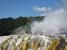
The most famous of the geysers in the area erupts about every hour and hurls water up to 30 meters high, but mostly much less.
Kereru geyser
The Kereru geyser, about 2 m above the Puarenga Stream , is located at the upper end of a small black sintered apron and erupts every few days or weeks in a fan up to 15 m high. There were no major outbreaks between 1972 and 1988. The recovery after that is apparently related to the closure of the wells around the site from 1987 onwards. The geyser may be separate from the others on the same fault.
Prince of Wales Feathers -Geyser
The Prince of Wales Feathers Geyser is located along with the, Pohutu Geyser, Te-Horu Geyser and Waikorohihi Geyser on a sintered plateau about 6 m above the river. The Prince of Wales Feathers Geyser is the closest neighbor of Pohutu and breaks always out in front of this. A weak beam intensifies to a sloping column up to 9 m high when the Pohutu erupts. Sometimes the Waikorohihi Geyser also begins with an uneven, 5 m high beam, then the Prince of Wales Feathers , later the Pohutu.
Te Horu Geyser
By 1972 this geyser erupted 10 to 15 times at a height of 2 to 7 m, after which it stopped and the water in the chimney cooled off. In 1998 the water began to come out of the chimney again. There is a relationship between the Te Horu and the Pohutu: large parts of the water of the Pohutu, cooled in the air, fall into the chimney of the Te Horu. This could confirm the opinion that the Pohutu is more active in southerly winds, when most of the water from the eruptions is blown north, while northerly winds bring a lot of cool water into the system and delay the next eruption.
Mahanga geyser
The Mahanga geyser, also Boxing Glove ("boxing glove") is an old geyser, of which no eruption is recorded until 1961. Its 3–4.5 m high column appears to be quite independent of its neighbor Waikorohihi.
Wairoa Geyser
The Wairoa is said to have reached a height of up to 60 m in the past. It last erupted in December 1940, after which its water level fell to 4.5 m below the overflow and the water became acidic. At the beginning of 1996 the water rose to 3.2 m below the overflow and has been boiling since then.
Waikite Geyser
The geyser is located below the Geyser Flat on the summit of a sinter hill 260 m south of the Pohutu. It last erupted in March 1967, after which the 8.5 m deep chimney remained dry and emitted very little steam. In June 1996 the chimney suddenly filled up to 2.3 m below the overflow with boiling water. In the past, the Waikite was prone to eruptions after prolonged heavy rains.
Papakura geyser
The Papakura Geyser is another dormant geyser. It last erupted in March 1979 after having worked for 90 years with three short breaks. The failure of the papakura to erupt was the direct cause of the program to monitor geothermal activities in Rotorua in 1981. In October 1997, the water in the chimney warmed to 60 ° C and became clear and alkaline again.
Blue pool
The Blue Pool or Bluey is a thermal lake so named because of its blue color with strongly alkaline water at 30–50 ° C water temperature. The lake, which was previously used as a bathing lake, collects the water expelled by the geysers and flows underground into the Puarenga Stream. There are sintered stumps of manuka trees on the north and west sides .
Mud pots
In addition to the thermal springs and geysers, there are numerous mud pots on the site.
graveyard
There is a Māori cemetery, which is not open to the public, on a hill on the site. Since the soil is not suitable for burials because of its temperature, the dead are buried above ground in brick tombs.
Pā
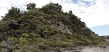
Since 1325, the Māori - Pā Te Puia, surrounded by wooden palisades, stood on a hill with steeply sloping sides . It was part of the Te Arawa defense system, which was centered on Mokoia Island in Lake Rotorua .
Te Heketanga a Rangi
A modern building was created in the entrance area of the site, in which carvings are made in a circular arrangement, embodying the Māori gods. In the middle there is a large stone made of pounamu (jade) in a small water basin , which is touched when leaving the area.
Marae
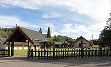
The Rotowhio- Marae with the meeting house Te Aranui a Rua is located on the site . In addition to their role as a meeting place for the tribe, they are used for tourism. Every day, after a traditional welcoming ceremony, there are demonstrations of haka and poi in the meeting house, in which the visitors are also involved. A dinner with food from the hangi will then take place in an adjoining restaurant , followed by a visit to the geothermal field.
Other facilities
The only Māori carving school and weaving school are located in buildings opposite on the site. There is also a replica of a Māori village with huts, a storehouse and a hangi, and a night house where you can watch kiwis . There are also tours on the premises with a motor train.
Web links
- Whakarewarewa Thermal Village (English)
- Rotorua Maori Culture and Geothermal at New Zealand News
- Te Piua Te Whakarewarewa Thermal Valley , Rotorua , New Zealand . Te Puia,accessed January 13, 2016.
Individual evidence
- ↑ information board on site; Wahio was an ancestor of the residents of the area and a chief of the Ngati Wahio, a sub-tribe of the Te Arawa
- ↑ Whakarewarewa. Description by Whakarewarewa on New Zealand on the Web
- ^ Whakarewarewa Thermal Valley . Archived from the original on April 17, 2007. Retrieved May 10, 2007.
- ↑ Information board at the Blue Pool
- ↑ Information board at the former Pā square
Coordinates: 38 ° 9 ′ 44 ″ S , 176 ° 15 ′ 23 ″ E


