
Rotorua
| Rotorua | ||
| Geographical location | ||
|
||
| Coordinates | 38 ° 8 ′ S , 176 ° 15 ′ E | |
| Region ISO | NZ-BOP | |
| Country |
|
|
| region | Bay of Plenty | |
| District | Rotorua Lakes | |
| Administrative headquarters | Administrative headquarters for the Rotorua Lakes | |
| Local foundation | early 1880s | |
| Residents | 53 265 (2013) | |
| height | 287 m | |
| Post Code | 3010, 3015 | |
| Telephone code | +64 (0) 7 | |
| UN / LOCODE | NZ RED | |
| Photography of the place | ||
 Rotorua |
||

Rotorua is a city in the Rotorua Lakes district of the Bay of Plenty region on the North Island of New Zealand . The city is the seat of the Rotorua Lakes Council and is also very popular as a health resort.
Origin of name
When it was founded , the city was named after the lake of the same name, which an ancestor of the Te Arawa tribe discovered as the second lake after Lake Rotoiti and was therefore named by him. In the Māori language , “rotu” means sea and “rua” means two.
geography
The city is located around 53 km south of Tauranga at the southern end of Lake Rotorua , the second largest lake on the North Island after Lake Taupo . The city of Hamilton is approximately 94 km to the west-northwest and the city of Taupo and 62 km to the south-southwest.
geology
Rotorua is known for its "bubbling pools" and the omnipresent smell of sulfur in the city, which is part of the North Island Volcanic Plateau with its surrounding area and here in particular geothermal and volcanic activities such as geysers , hot water springs and bubbling mud pools and ponds can be observed are. In many places in the city, hot steam with a sulphurous smell emerges from pools and crevices, which is a tourist attraction on the one hand and indicates that the city was built on a volcano on the other. Many of its thermal springs are used for baths and spa facilities or for heating in the cooler seasons.
After sustained heavy rainfall, with a local record value of hourly precipitation, a crevice about 200 m long, up to 30 m wide and up to 20 m deep formed in a meadow and pasture landscape near Rotorua .
| Rotorua | ||||||||||||||||||||||||||||||||||||||||||||||||
|---|---|---|---|---|---|---|---|---|---|---|---|---|---|---|---|---|---|---|---|---|---|---|---|---|---|---|---|---|---|---|---|---|---|---|---|---|---|---|---|---|---|---|---|---|---|---|---|---|
| Climate diagram | ||||||||||||||||||||||||||||||||||||||||||||||||
| ||||||||||||||||||||||||||||||||||||||||||||||||
history
The area around Rotorua has been the settlement area of the Te Arawa tribe since the 14th century . In the 1860s, the area was a major site of the New Zealand Wars . Twenty years later, the area around Rotorua was declared a " special town district " in order to privilege Rotorua's potential as a health resort. Until 1886, the Pink and White Terraces , a popular destination that was completely destroyed when the Tarawera volcano erupted, were not far from here at Tarawera .
population
At the 2013 census, the city had 53,265 inhabitants. Almost 40% of the population belong to the Māori ethnic group , making Rotorua the city with the second highest proportion of Māori within the city's population after Gisborne .
economy
By far the most important economic sector in the city is tourism. Rotorua is also the commercial and service center of the district, in which after tourism, agriculture and forestry are the most important sources of income. Sheep and cattle breeding is of great importance in agriculture. In the city itself there are also industrial companies that manufacture building materials, produce wire ropes or also manufacture chemical end products for end users.
Infrastructure
Road traffic
Four New Zealand State Highways converge in and around Rotorua , two of which run through the city. The New Zealand State Highway 5 , coming from the northwest from the direction of Hamilton , crosses the city and leads south to the city of Taupo . The New Zealand State Highway 30, on the other hand, comes from the east of Whakatāne , also runs right through the city and goes southwest to the Atiamuri power station . New Zealand State Highway 36 comes from Tauranga , from the north-north-west, and joins State Highway 5 at Ngongotaha , about 7 km from the city, and from Paengaroa from the north-north-east, New Zealand State Highway 30 ends at Te Ngae on the State Highway 30 , around 9 km northeast of the city.
Rail transport
In the northwest of Rotorua , a branch of a railway line finds its end point, which branches off from the Kinleith Branch at Putaruru and has a connection to Hamilton . However, the route has not been used for some time.
Attractions
In addition to the geothermal parks , the Pohutu Geyser , the thermal fields of Whakarewarewa near the city and the only Māori carving and art academy are the main attractions of the city. The botanical garden is also well known. Te Wairoa , a small town not far from Rotorua that was previously founded by both Māori and Europeans and was the starting point for the White and Pink Terraces until 1886 , is increasingly popular. A museum on the history of the settlement has been set up in the village, which was once buried by a volcanic eruption and dug up again.
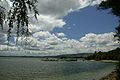
Lake Rotorua , north of the city

Rotorua Bathhouse (before 1913)
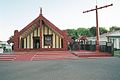
Māori meeting house in Rotorua


Personalities
- Temuera Morrison (born 1960), actor
- Susan Devoy (born 1964), squash player
- Cliff Curtis (born 1968), actor
- Valerie Kasanita Adams (* 1984), athlete and Olympic champion
- Logan Hutchings (* 1984), racing cyclist
- Steven Adams (born 1993), basketball player
- Richie Stanaway (* 1991), racing driver
Twin cities
-
 Beppu , Japan
-
 Klamath Falls , Oregon , USA
-
 Lake Macquarie , New South Wales , Australia
-
 Wuzhong District of Suzhou City , China
See also
literature
- Helga Neubauer: Rotorua . In: The New Zealand Book . 1st edition. NZ Visitor Publications , Nelson 2003, ISBN 1-877339-00-8 , pp. 325-331 .
Web links
- Homepage . Destination Rotorua,accessed October 14, 2017(English, tourismwebsite).
- Malcolm McKinnon : Volcanic Plateau places - Rotorua city . In: Te Ara - the Encyclopedia of New Zealand . Ministry for Culture & Heritage , May 25, 2015, accessed October 14, 2017 .
Individual evidence
- ^ A b Malcolm McKinnon : Volcanic Plateau places - Rotorua city . In: Te Ara - the Encyclopedia of New Zealand . Ministry for Culture & Heritage , May 25, 2015, accessed October 14, 2017 .
- ^ Neubauer: Rotorua . Nelson 2003, p. 330 .
- ↑ a b c Topo250 maps . Land Information New Zealand , accessed October 14, 2017 .
- ^ Neubauer: Rotorua . Nelson 2003, p. 325 f .
- ^ Huge hole in the ground discovered in New Zealand n-tv.de, May 4, 2018, accessed August 28, 2018.
- ^ Neubauer: Rotorua . Nelson 2003, p. 325 .