White Island (Otago)
| White Island | ||
|---|---|---|
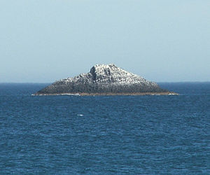
| White Island as seen from St. Clair Beach | ||
| Waters | Pacific Ocean | |
| Geographical location | 45 ° 56 '0.8 " S , 170 ° 29' 49.2" O | |
|
|
||
| length | 80 m | |
| width | 30 m | |
| Highest elevation | 15 m | |
| Residents | uninhabited | |
White Iceland is the name of an island 2.5 kilometers off the coast of Otago 's in New Zealand . Administratively it belongs to the city of Dunedin .
The island is 80 m long and 30 m wide at its widest point, its area is 1,600 m², the maximum height 15 m. A rocky reef, which partially breaks through the water surface at low tide, extends a further 100 m from the west end of the island into the sea.
The uninhabited island is a well-known landmark that can be seen from Dunedin's two urban beaches (St. Clair and St. Kilda).
The Māori call the island Ponuiahine , also Pomuiahine . This has been translated, perhaps too literally and ambiguously, as "the girl's great night". Goodall and Griffiths write in 'Māori Dunedin' that it should be understood more as 'Pou-nui-a-Hine', which refers to a post that is a memorial for an important event in which "Hine" is involved . "Hine" can be a man's name, everything else is left to speculation. The island does not seem very promising as a place for love adventures.
White Island may have been the Ragged Rock, where the Sydney seal hunter Brothers, under the command of Robert Mason, released three convicts from a group of 11 men, including William Tucker, in November 1809. Alternatively, Green Island could have been that island.
On May 1, 1826, the gardener Thomas Shepherd kept a diary when he approached this coast with the first settlers of the New Zealand Company on the Rosanna . She was accompanied by the Lambton . He reported seeing "two remarkable Sugar Loaf rocks" protruding about 100 feet out of the sea near the coast. A man was sent to the coast and came back with a Māori named Tatawa who "said he was of Otago".
A reef south of White Island can still be recognized today by the breaking sea, at the time of the expedition it may have jutted even higher out of the sea. When Dunedin was settled in 1848, there was only the island that is visible today.
In the early 1880s, a retractable Armstrong (" disappearing gun ") cannon , similar to the one that can still be seen today at Taiaroa Head , was installed at Forbury Head above St. Clair. It appears that White Island was used for targeting this cannon, which may have destroyed it and made it even more rugged.
Individual evidence
- ↑ Māori Dunedin, Otago Heritage Books, Dunedin, 1980, p. 49 (English)

