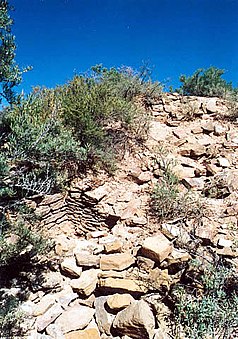
Yucca House National Monument
| Yucca House National Monument | ||
|---|---|---|
| Buried ruins at Yucca House NM | ||
|
|
||
| Location: | Colorado , United States | |
| Next city: | Cortez (Colorado) | |
| Surface: | 0.14 km² | |
| Founding: | December 19, 1919 | |
Yucca House is a national monument of the United States of America located in the southwestern part of the US state of Colorado . It protects the structures of an Anasazi settlement that have not yet been excavated and is located around 70 km west of Durango in Montezuma County . The buried ruins date from the 12th to 13th centuries and form one of the largest archaeological sites in southwest Colorado.
history
Yucca House was first mentioned in 1877 by Prof. William H. Holmes, a landscape researcher from the US Geological Survey (USGS), who called the two most obvious hills the Upper House and Lower House . The Upper House formed the imposing center of around 600 rooms and 100 kivas , which towered over the other buildings by around five to six meters. Holmes - who originally thought the settlement was an Aztec site and therefore called it Aztec Springs - also discovered at least eight other rooms in the Lower House , which, in addition to a central kiva, formed an L-shaped pueblo and were enclosed by a small wall.
The name of the Yucca House goes back to the earlier name used by the Anasazi for Sleeping Ute Mountain , at the foot of which the settlement was built. The name used at that time due to the mountain vegetation was "mountain full of yucca ".
National monument
The Yucca House was declared a national monument by US President Woodrow Wilson in late 1919 and was added to the National Register of Historic Places on October 15, 1966. The site, which has no service facilities, is managed by the administration of the nearby Mesa Verde National Park and can be entered free of charge.
Web links
- National Park Service: Yucca House National Monument (official site; English)

