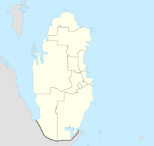
Zekrit (fortress)
Coordinates: 25 ° 28 ′ 53.8 " N , 50 ° 50 ′ 41.2" E
Zekrit was a fortress built in the late 18th or early 19th century by an Arab tribal prince on the west coast of the Ras Abaruk peninsula in what is now the Emirate of Qatar . The fortification was the southernmost point in a chain of smaller bases classified as a coastal fort in contemporary English and Arabic accounts .
location
Zekrit was in a topographically favorable position at the entrance to the port of As Salwa and other ports and locations on the west coast of the Qatar peninsula. Because of the desert-like hinterland, trade was concentrated in the coastal region.
history
On the Gulf coast, near the present-day town of Bir Zekrit in the Emirate of Qatar, there have been some watering points and wells since the Middle Ages that were used by coastal fishermen and sailors and that were built around 1800 by an Arab tribal leader Rahmat b. Jabayr were annexed in order to be able to build a fortification at this place, which could be useful in his strategic plans for the attainment of dominance in this area of the Arabian Peninsula. From British reports it is known that the place was abandoned as a fortification from 1845. Nothing is known about the type and extent of armament in the fortress.
description
The structure is only 40 meters from the shore and is located on a hill above the natural harbor Zekrit, it was fortified according to the typical regional construction. The system had a trapezoidal floor plan, the main axes are 52.20 m and 45 m long. There were towers at the four corners, two towers were circular and two were roughly square. The height of three towers was estimated, the southwest tower was examined more closely, it reaches a total height of 4.28 m in the middle, its outer walls are preserved at a height of 2.35 m. The walls of the fortress were originally at least eight feet high. Two entrances were discovered: the south gate is 6.5 m wide and may have been used as the main entrance, the second opening is a small door, only 1.40 m wide, located on the north side of the fortress. The remains of the previously uncovered buildings are between 0.80 m and 2.35 m high. The uppermost parts of the wall structure consist of a layer of stones and sand, under each of which there is a layer of gypsum of uneven thickness (measurement between 0.10 and 0.52 m).
So far, an enclosure wall and a stone building have been exposed, these were in the immediate vicinity of the wells and water tanks. The excavators suspect that the site was only used temporarily, for example for piracy or as a safe haven for coastal shipping. The supply of the crew was secured by sea, for this purpose dates were delivered from the Bahrain region . This is also confirmed by an artisanal processing zone of dates into syrup known as madbassa . An excavation cut enabled the discovery of some ceramics from the Abbassid period, from which it is concluded that the water points were at least temporarily (in the 9th century) of strategic importance and that there was at times a "field camp".
meaning
The joint research project "Zekir" was started in 2002 by the Emirate of Qatar and the Republic of France . The scientific research program also includes the creation of an archaeological atlas of the Emirates of Qatar and a database of finds. In an extended project phase, the cultural heritage of the country is to be documented and rooted through the involvement of schools, private organizations and associations from the region, for this purpose a visit to the excavation site, the establishment of working groups for the fine arts and exhibitions.
Individual evidence
- ↑ a b questions. In: France Diplomatie, Archeology Reports - Africa and Arab States. Retrieved August 31, 2010 .
- ↑ Zekrit (Qatar). In: France Diplomatie, Archeology Reports - Africa and Arab States. Retrieved August 31, 2010 .
- ↑ Alexandrine Guérin, Faysal Κ Abdallah al-NaMimi: Nineteenth century settlement patterns at Zekrit, Qatar: pottery, tribes and territory . (No longer available online.) In: GROUPE DE RECHERCHES ET D'ÉTUDES SUR LA MÉDITERRANÉE ET LE MOYEN-ORIENT. Formerly in the original ; Retrieved October 8, 2010 . ( Page no longer available , search in web archives ) (PDF, English)
literature
- Alexandrine Guérin: Territoires et peuplement à la période abbasside Zékrit et Murwab, Emirate de Qatar - Golfe arabo-persique: rapport de la première campagne archéologique novembre-décembre 2002 . Lyon 2002.
- Alexandrine Guérin, Pascal Mongne: Mission archeologique françaises de Zekrit à Èmirat Qatar . In: Ministère des affaires étrangères de France (ed.): Archéologies: vingt ans de recherches françaises dans le monde . Maisonneuve et Larose ..., Paris 2005, ISBN 2-7068-1873-5 , p. 540-541 .
