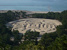
Zenigata Sunae
Zenigata Sunae ( Japanese 銭 形 砂 絵 , English "coin-shaped sand picture") is a large sand picture that depicts a Japanese coin. The extension is 122 m from east to west, 90 m from north to south and the circumference is 345 m. The picture is located on Ariake Beach ( 有 明 浜 , Ariake no hama ) of the Seto Inland Sea in Kotohiki Park ( 琴 弾 公園 , Kotohiki-kōen ) of the city of Kan'onji on Shikoku Island . The coin shown is a Kan'ei Tsūhō ( 寛 永 通宝 ) - "Kan'ei coin", where Kan'ei denotes the era from 1624 to 1643, in which this type of coin was introduced.
The exact origin of this sand picture is unclear. There are essentially three theories:
- The best-known tradition, which is also cited by the city, is that the picture was erected overnight by the villagers in 1633 in honor of the daimyo Ikoma Takatoshi of the fiefdom ( han ) Marugame , who was on his inspection tour. However, the Kan'ei coins were not introduced until 1636 and the inspection trip is unoccupied.
- The book Kan'onji-shi-shi ( 観 音 寺 市 史 , Eng. "History of the City of Kan'onji") from 1962 cites the date of creation more than 200 years later around 1855. The Shogunate then instructed the individual fiefs to strengthen the coastal fortifications. When the Daimyō Kyōgoku Akiyuki wanted to convince himself of the progress of the coastal batteries on Ariake Beach, the commissioner responsible for the construction ( 普 請 奉行 , fushin bugyō ) put this picture on for the amusement of the daimyō.
- According to another theory, the picture was created in 1633, but was originally the bottle gourd symbol of the Toyotomi clan, which fell apart in 1615 , in the hope that it would flourish again. This stood in opposition to the ruling shogunate clan of the Tokugawa , so that in order not to come under suspicion of high treason, the sand picture was later changed to its current form of coin.
The sand picture is repaired every six months in spring and autumn.
swell
- 銭 形 砂 絵 「寛 永 通宝」 . Kan'onji city, March 22, 2016,accessed August 22, 2016(Japanese).
- Kazuki Kuroshima ( 黒 島 一 樹 ): 有 明 浜 の 銭 形 砂 絵 (観 観 音 寺 市) . Shikoku Shimbun- sha, accessed September 25, 2009 (Japanese).
Coordinates: 34 ° 8 ′ 2.9 " N , 133 ° 38 ′ 32.2" E

