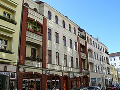
Zillestrasse (Berlin)
| Zillestrasse | |
|---|---|
| Street in Berlin | |
| Zillestrasse 71 | |
| Basic data | |
| place | Berlin |
| District | Charlottenburg |
| Created | around 1720 |
| Hist. Names |
Wallstrasse (around 1720–1933) , Maikowskistraße (1933–1947) |
| Cross streets |
(Selection) Otto-Suhr-Allee , Richard-Wagner-Strasse, Wilmersdorfer Strasse , Schloßstrasse |
| use | |
| User groups |
Pedestrian traffic , bicycle traffic , car traffic |
| Technical specifications | |
| Street length | 1190 meters |
The Zillestraße is a street in the Berlin district of Charlottenburg . It begins on Schloßstraße and initially runs in an easterly direction. For the last 120 meters, it bends north and flows into Otto-Suhr-Allee .
history
From 1720 to 1933 the street was called Wallstraße . In a map of the city of Charlottenburg from 1724, it is shown as Circulations Street . The Charlottenburg chronicler Wilhelm Gundlach also writes of a circumvallation street . The development on the edge of Wallstrasse and its northern extension, Rosinenstrasse (today: Loschmidtstrasse), replaced the missing excise and city wall .
Wallstrasse originally ended at Wilmersdorfer Strasse . According to the plan from 1724, a palisade through the adjacent swamp area of the Lietzenseegraben and the Schwarzer Graben was planned as a western extension . However, this city fortification was never realized. Until the middle of the 19th century, the Wallstrasse / Rosinenstrasse axis formed the southern and eastern boundary of Charlottenburg. After the underground canalization of the Black Trench in 1889 and the filling of the wetland of the former carp pond, Wallstrasse was extended westward to Schloßstrasse.
At the beginning of the 1930s there were violent clashes between supporters of the KPD and the National Socialists in the street, which was mostly inhabited by workers . On January 30, 1933, the day the National Socialists came to power , the SA leader Hans Maikowski and the police officer accompanying him, Josef Zauritz, were shot in Zillestrasse under circumstances that were never entirely clear. The name of the street was changed to Maikowskistraße on August 2, 1933 . In the process 56 people from the left spectrum were indicted and many were sentenced to long prison terms without being able to prove that they were involved in the crime. After the Second World War , strong evidence was found that pointed to the SA man Alfred Buske as the murderer of Maikowski and Zauritz. Another argument began here when, on February 17, 1933, members of the “Lange” house protection squad led by Richard Hüttig met two SS men at the intersection with Wilmersdorfer Strasse . During the clashes, SS-Scharführer Kurt von der Ahé was shot near the SS restaurant in Koch on Schillerstrasse, as the court found probably by the SA man Amor, who mistakenly believed Ahé to be a communist. Nevertheless, the court passed a death sentence against Hüttig and high prison sentences against other members of the house protection squad. At the House of Youth at No. 54 there is a memorial plaque for those in the Maikowski trial and in the trial of the murder of Charlottenburg opponents of National Socialism who were probably wrongly convicted by von der Ahé.
Wallstrasse became known through the book Our Street by the writer and anti-fascist Jan Petersen , who lived in Charlottenburg at the time, and who described the disputes described above at risk of death in the form of a novel .
In 1945 or 1946 the street was named after the graphic artist , draftsman and honorary citizen of Berlin Heinrich Zille , who lived in the nearby Sophie-Charlotten-Straße for almost 40 years until his death in 1929.
Development and monument protection
Large parts of the development were destroyed during the Second World War . Among many others, the tenement house No. 71 built by Hermann Günther and F. Langner in 1895/1896 and now a listed building, and the listed residential complex No. 97-103 by Erich Köhne built in 1905/1906, as well as one at the turn of the 20th century, have been preserved Built tenement house at No. 75.
literature
- Wilhelm Gundlach: History of the city of Charlottenburg. 2 volumes, Springer, Berlin 1905.
- Sonja Miltenberger: Charlottenburg in historical maps and plans , Jaron, Berlin 1998, ISBN 3-932202-32-5 .
- Jan Petersen : Our street . Pahl-Rugenstein, Cologne 1983, ISBN 3-7609-0752-0 ( marxists.org ).
Web links
- Zillestrasse. In: Street name lexicon of the Luisenstädtischer Bildungsverein (near Kaupert )
- Information page of the district office
- Information on the memorial plaque at the district office
Individual evidence
- ^ Wilhelm Gundlach: The history of the city of Charlottenburg. Springer publishing house. Berlin 1905, p. 449
- ↑ Gundlach, Volume I, p. 77
- ↑ Location plan of the city of Charlottenburg 1724 by Remarque. In: Wilhelm Gundlach: History of the city of Charlottenburg . Springer Verlag, Berlin 1905
- ↑ Gundlach, Vol. I, p. 547
- ↑ Harald Marpe: Political map of Alt-Charlottenburg, Ed .: Kiezbündnis Klausenerplatz (self-published), Berlin 2013. P. 19 f
Coordinates: 52 ° 30 ′ 48.3 " N , 13 ° 18 ′ 19.9" E


