Old town (Plauen)
|
Old town
City of Plauen
Coordinates: 50 ° 29 ′ 38 ″ N , 12 ° 8 ′ 9 ″ E
|
|
|---|---|
| Residents : | 514 (May 9, 2011) |
| Postcodes : | 08523, 08527 |
| Area code : | 03741 |
|
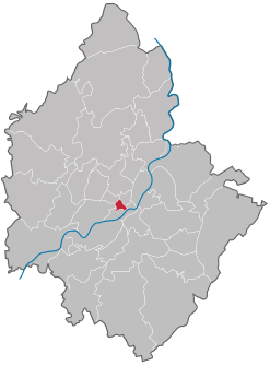
Location of the old town district in Plauen
|
|
Altstadt is one of the smallest districts of Plauen in the city center . Here is the historic center of the city with the town hall and the Johanniskirche .
geography
The old town is in the center of Plauen and borders five other districts.
| Dobenau | Schlossberg | |
| Neundorfer suburb |

|
Neustadt |
| Upper floodplain |
The old town is bounded by (clockwise from the north) Postplatz, Syrastrasse, Hofwiesenstrasse, Pfortenstrasse, Bleichstrasse, Böhlerstrasse, Mühlberg, Oberen and Unteren Graben. Approximately in the middle is the old market with the old town hall. In the north, at Postplatz, there is the central “Tunnel” stop for the Plauen tram . The head office of Sparkasse Vogtland is located in the south-western tip and above it is the Johanniskirche . The Weisbachsche Haus is located on the south-western border and the Malzhaus is in the immediate vicinity, the remains of a first town castle of the Ebersteiners on the southwest corner of the wall ring. To the east, between Obere Graben and Nobelstrasse, are the Vogtland Museum and the Erich-Ohser-Haus . The entrance to the New Town Hall is on the north-western border.
Individual evidence
- ↑ Population of the district in the 9th Official Statistics Report 2014, Chapter 5.02. Retrieved February 10, 2016 .


